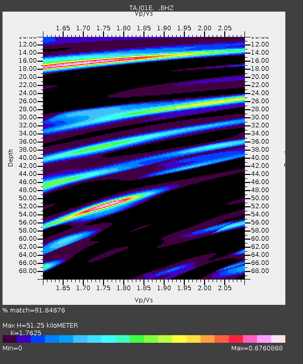
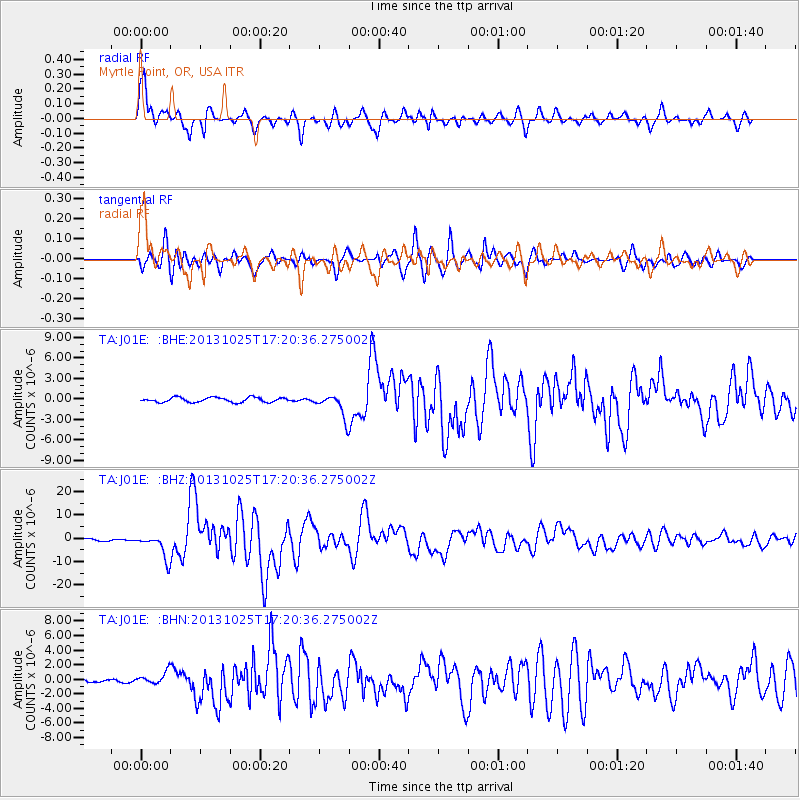
J01E Myrtle Point, OR, USA - Earthquake Result Viewer

Earthquake location: Off East Coast Of Honshu, Japan
Earthquake latitude/longitude: 37.2/144.7
Earthquake time(UTC): 2013/10/25 (298) 17:10:19 GMT
Earthquake Depth: 35 km
Earthquake Magnitude: 7.1 MWW, 7.1 MWW, 7.1 MWB, 7.1 MWC, 7.2 MWC, 7.5 MI
Earthquake Catalog/Contributor: NEIC PDE/NEIC COMCAT
Network: TA USArray Transportable Network (new EarthScope stations)
Station: J01E Myrtle Point, OR, USA
Lat/Lon: 43.16 N/123.93 W
Elevation: 128 m
Distance: 66.7 deg
Az: 52.793 deg
Baz: 299.584 deg
Ray Param: 0.05738548
Estimated Moho Depth: 51.25 km
Estimated Crust Vp/Vs: 1.76
Assumed Crust Vp: 6.522 km/s
Estimated Crust Vs: 3.7 km/s
Estimated Crust Poisson's Ratio: 0.26
Radial Match: 91.64676 %
Radial Bump: 400
Transverse Match: 90.79968 %
Transverse Bump: 400
SOD ConfigId: 626651
Insert Time: 2014-04-19 06:09:07.152 +0000
GWidth: 2.5
Max Bumps: 400
Tol: 0.001

Signal To Noise

ChannelStoNSTALTA
TA:J01E: :BHZ:20131025T17:20:36.275002Z12.8186295.1935085E-64.0515317E-7
TA:J01E: :BHN:20131025T17:20:36.275002Z2.41057548.400967E-73.4850464E-7
TA:J01E: :BHE:20131025T17:20:36.275002Z5.0695811.7267001E-63.4060017E-7
Arrivals
Ps6.2 SECOND
PpPs21 SECOND
PsPs/PpSs27 SECOND