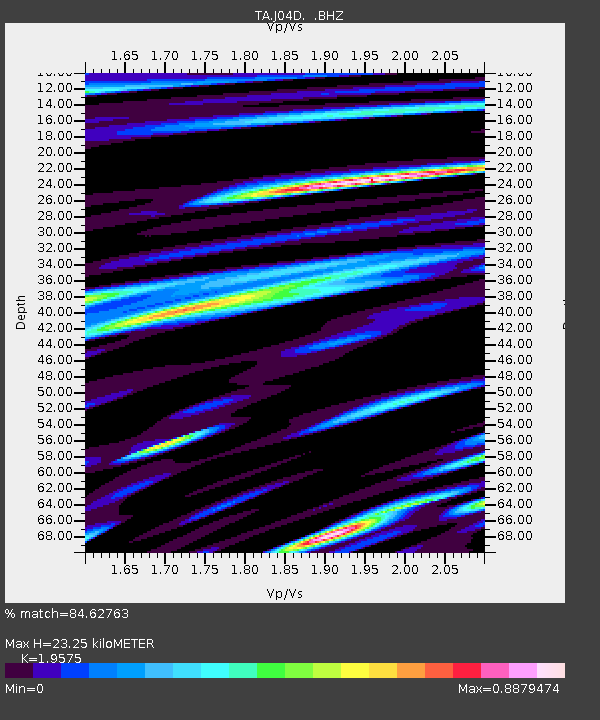
J04D Umpqua National Forest, Toketee, OR, USA - Earthquake Result Viewer

Earthquake location: Off East Coast Of Honshu, Japan
Earthquake latitude/longitude: 37.2/144.7
Earthquake time(UTC): 2013/10/25 (298) 17:10:19 GMT
Earthquake Depth: 35 km
Earthquake Magnitude: 7.1 MWW, 7.1 MWW, 7.1 MWB, 7.1 MWC, 7.2 MWC, 7.5 MI
Earthquake Catalog/Contributor: NEIC PDE/NEIC COMCAT
Network: TA USArray Transportable Network (new EarthScope stations)
Station: J04D Umpqua National Forest, Toketee, OR, USA
Lat/Lon: 43.24 N/122.11 W
Elevation: 1948 m
Distance: 67.8 deg
Az: 51.995 deg
Baz: 300.519 deg
Ray Param: 0.05665659
Estimated Moho Depth: 23.25 km
Estimated Crust Vp/Vs: 1.96
Assumed Crust Vp: 6.522 km/s
Estimated Crust Vs: 3.332 km/s
Estimated Crust Poisson's Ratio: 0.32
Radial Match: 84.62763 %
Radial Bump: 400
Transverse Match: 89.743126 %
Transverse Bump: 400
SOD ConfigId: 626651
Insert Time: 2014-04-19 06:09:12.444 +0000
GWidth: 2.5
Max Bumps: 400
Tol: 0.001

Signal To Noise

ChannelStoNSTALTA
TA:J04D: :BHZ:20131025T17:20:43.324014Z20.469135.9013396E-62.883044E-7
TA:J04D: :BHN:20131025T17:20:43.324014Z3.36605539.243136E-72.7459845E-7
TA:J04D: :BHE:20131025T17:20:43.324014Z4.4150951.3288039E-63.009684E-7
Arrivals
Ps3.5 SECOND
PpPs10 SECOND
PsPs/PpSs14 SECOND