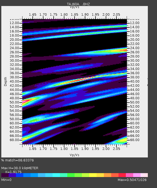
J60A Lant Hill Farm, Argyle, NY, USA - Earthquake Result Viewer
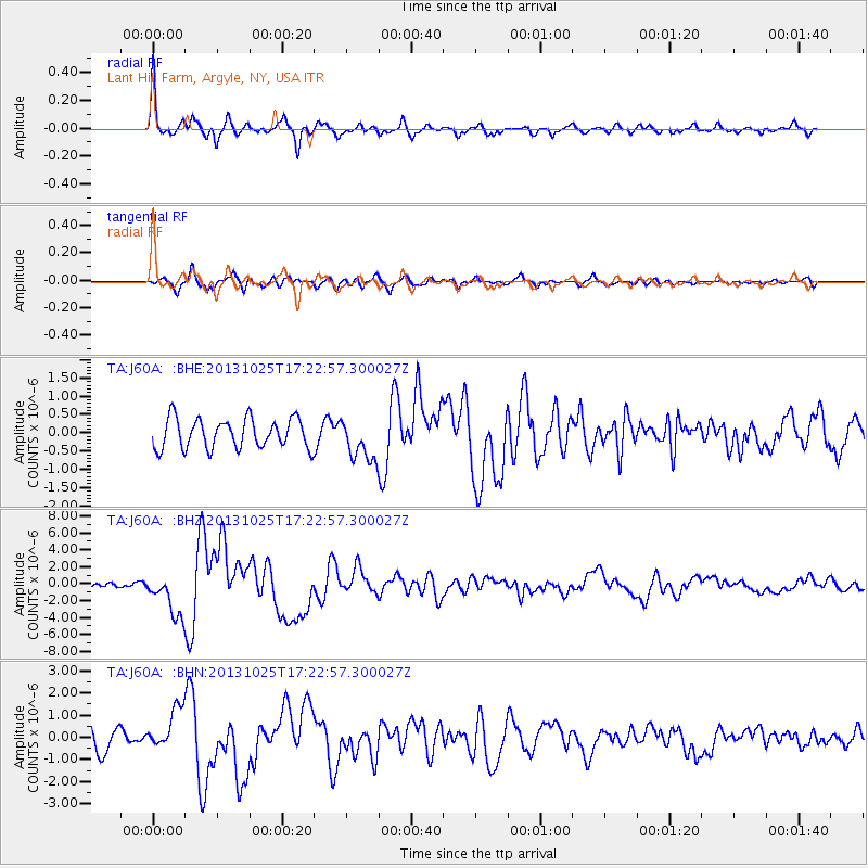
Earthquake location: Off East Coast Of Honshu, Japan
Earthquake latitude/longitude: 37.2/144.7
Earthquake time(UTC): 2013/10/25 (298) 17:10:19 GMT
Earthquake Depth: 35 km
Earthquake Magnitude: 7.1 MWW, 7.1 MWW, 7.1 MWB, 7.1 MWC, 7.2 MWC, 7.5 MI
Earthquake Catalog/Contributor: NEIC PDE/NEIC COMCAT
Network: TA USArray Transportable Network (new EarthScope stations)
Station: J60A Lant Hill Farm, Argyle, NY, USA
Lat/Lon: 43.24 N/73.42 W
Elevation: 265 m
Distance: 92.8 deg
Az: 26.824 deg
Baz: 330.437 deg
Ray Param: 0.041373443
Estimated Moho Depth: 38.0 km
Estimated Crust Vp/Vs: 1.92
Assumed Crust Vp: 6.419 km/s
Estimated Crust Vs: 3.348 km/s
Estimated Crust Poisson's Ratio: 0.31
Radial Match: 86.63376 %
Radial Bump: 373
Transverse Match: 70.01303 %
Transverse Bump: 400
SOD ConfigId: 626651
Insert Time: 2014-04-19 06:09:46.580 +0000
GWidth: 2.5
Max Bumps: 400
Tol: 0.001

Signal To Noise

ChannelStoNSTALTA
TA:J60A: :BHZ:20131025T17:22:57.300027Z6.22779752.5026236E-64.0184727E-7
TA:J60A: :BHN:20131025T17:22:57.300027Z2.2810849.4707434E-74.1518607E-7
TA:J60A: :BHE:20131025T17:22:57.300027Z1.39572395.685489E-74.0735057E-7
Arrivals
Ps5.5 SECOND
PpPs17 SECOND
PsPs/PpSs22 SECOND