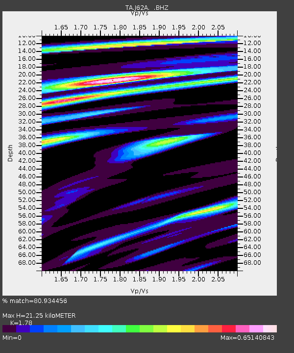
J62A Henniker, NH, USA - Earthquake Result Viewer
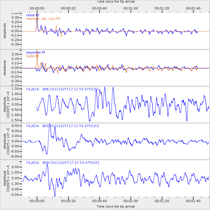
Earthquake location: Off East Coast Of Honshu, Japan
Earthquake latitude/longitude: 37.2/144.7
Earthquake time(UTC): 2013/10/25 (298) 17:10:19 GMT
Earthquake Depth: 35 km
Earthquake Magnitude: 7.1 MWW, 7.1 MWW, 7.1 MWB, 7.1 MWC, 7.2 MWC, 7.5 MI
Earthquake Catalog/Contributor: NEIC PDE/NEIC COMCAT
Network: TA USArray Transportable Network (new EarthScope stations)
Station: J62A Henniker, NH, USA
Lat/Lon: 43.23 N/71.81 W
Elevation: 266 m
Distance: 93.4 deg
Az: 25.803 deg
Baz: 331.59 deg
Ray Param: 0.041257776
Estimated Moho Depth: 21.25 km
Estimated Crust Vp/Vs: 1.78
Assumed Crust Vp: 6.419 km/s
Estimated Crust Vs: 3.606 km/s
Estimated Crust Poisson's Ratio: 0.27
Radial Match: 80.934456 %
Radial Bump: 334
Transverse Match: 59.152096 %
Transverse Bump: 400
SOD ConfigId: 626651
Insert Time: 2014-04-19 06:09:51.752 +0000
GWidth: 2.5
Max Bumps: 400
Tol: 0.001

Signal To Noise

ChannelStoNSTALTA
TA:J62A: :BHZ:20131025T17:22:59.975015Z4.24441532.491873E-65.870945E-7
TA:J62A: :BHN:20131025T17:22:59.975015Z1.6291826.1420127E-73.769998E-7
TA:J62A: :BHE:20131025T17:22:59.975015Z1.72517598.396121E-74.8668204E-7
Arrivals
Ps2.6 SECOND
PpPs9.0 SECOND
PsPs/PpSs12 SECOND