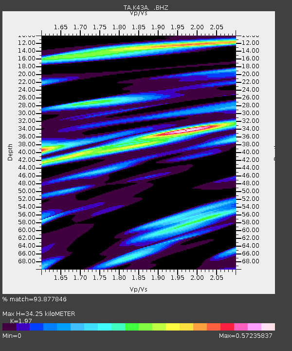
K43A Burlington, WI, USA - Earthquake Result Viewer
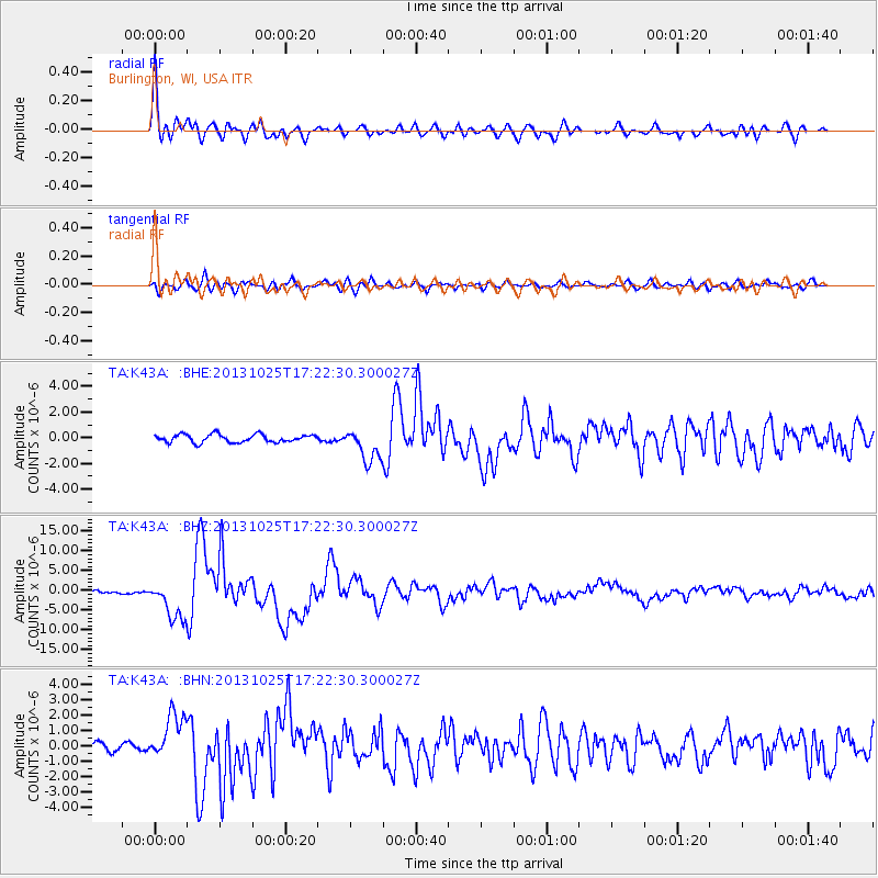
Earthquake location: Off East Coast Of Honshu, Japan
Earthquake latitude/longitude: 37.2/144.7
Earthquake time(UTC): 2013/10/25 (298) 17:10:19 GMT
Earthquake Depth: 35 km
Earthquake Magnitude: 7.1 MWW, 7.1 MWW, 7.1 MWB, 7.1 MWC, 7.2 MWC, 7.5 MI
Earthquake Catalog/Contributor: NEIC PDE/NEIC COMCAT
Network: TA USArray Transportable Network (new EarthScope stations)
Station: K43A Burlington, WI, USA
Lat/Lon: 42.70 N/88.33 W
Elevation: 264 m
Distance: 87.0 deg
Az: 36.117 deg
Baz: 320.292 deg
Ray Param: 0.04357709
Estimated Moho Depth: 34.25 km
Estimated Crust Vp/Vs: 1.97
Assumed Crust Vp: 6.571 km/s
Estimated Crust Vs: 3.335 km/s
Estimated Crust Poisson's Ratio: 0.33
Radial Match: 93.877846 %
Radial Bump: 400
Transverse Match: 81.812965 %
Transverse Bump: 400
SOD ConfigId: 626651
Insert Time: 2014-04-19 06:10:05.603 +0000
GWidth: 2.5
Max Bumps: 400
Tol: 0.001

Signal To Noise

ChannelStoNSTALTA
TA:K43A: :BHZ:20131025T17:22:30.300027Z10.2213924.941858E-64.834819E-7
TA:K43A: :BHN:20131025T17:22:30.300027Z5.400641.4996365E-62.7767754E-7
TA:K43A: :BHE:20131025T17:22:30.300027Z4.1345171.2633138E-63.055529E-7
Arrivals
Ps5.2 SECOND
PpPs15 SECOND
PsPs/PpSs20 SECOND