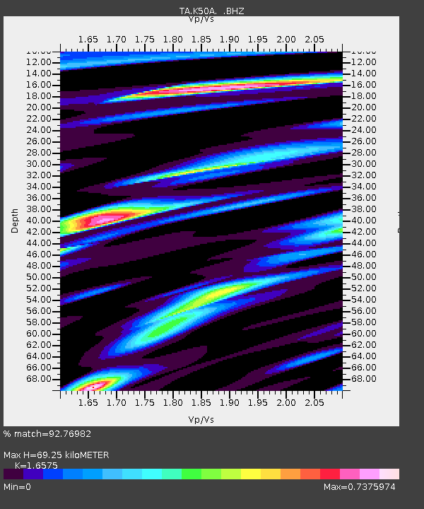
K50A Casco, MI, USA - Earthquake Result Viewer
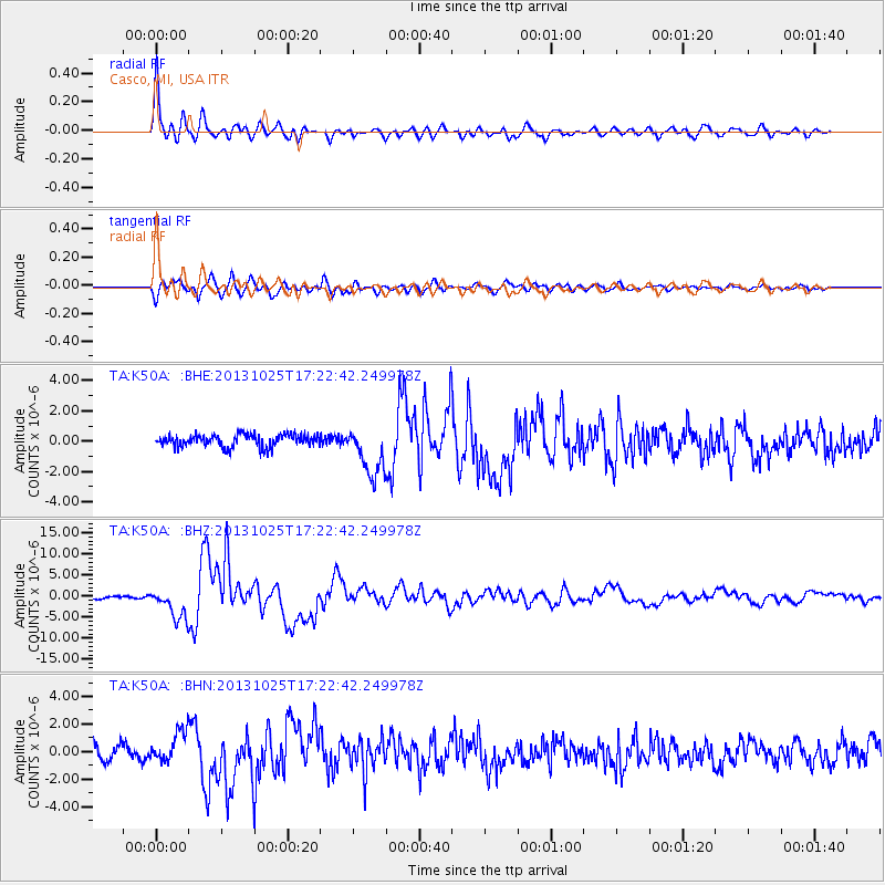
Earthquake location: Off East Coast Of Honshu, Japan
Earthquake latitude/longitude: 37.2/144.7
Earthquake time(UTC): 2013/10/25 (298) 17:10:19 GMT
Earthquake Depth: 35 km
Earthquake Magnitude: 7.1 MWW, 7.1 MWW, 7.1 MWB, 7.1 MWC, 7.2 MWC, 7.5 MI
Earthquake Catalog/Contributor: NEIC PDE/NEIC COMCAT
Network: TA USArray Transportable Network (new EarthScope stations)
Station: K50A Casco, MI, USA
Lat/Lon: 42.77 N/82.62 W
Elevation: 191 m
Distance: 89.5 deg
Az: 32.751 deg
Baz: 324.054 deg
Ray Param: 0.041732524
Estimated Moho Depth: 69.25 km
Estimated Crust Vp/Vs: 1.66
Assumed Crust Vp: 6.483 km/s
Estimated Crust Vs: 3.911 km/s
Estimated Crust Poisson's Ratio: 0.21
Radial Match: 92.76982 %
Radial Bump: 400
Transverse Match: 76.341385 %
Transverse Bump: 400
SOD ConfigId: 626651
Insert Time: 2014-04-19 06:10:17.616 +0000
GWidth: 2.5
Max Bumps: 400
Tol: 0.001

Signal To Noise

ChannelStoNSTALTA
TA:K50A: :BHZ:20131025T17:22:42.249978Z9.8797243.579088E-63.62266E-7
TA:K50A: :BHN:20131025T17:22:42.249978Z2.06902071.1135261E-65.3818997E-7
TA:K50A: :BHE:20131025T17:22:42.249978Z4.04826971.6564273E-64.0916925E-7
Arrivals
Ps7.2 SECOND
PpPs28 SECOND
PsPs/PpSs35 SECOND