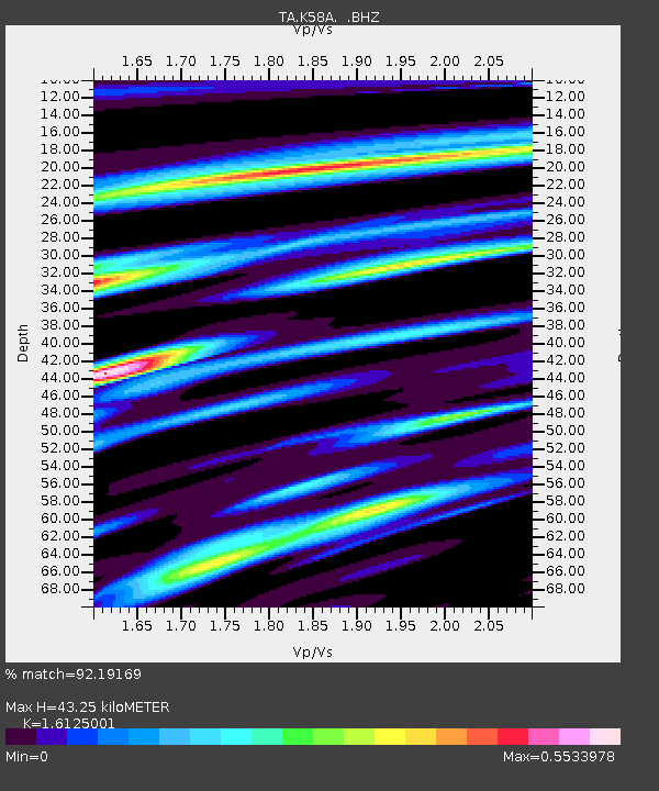
K58A Earlville, NY, USA - Earthquake Result Viewer

Earthquake location: Off East Coast Of Honshu, Japan
Earthquake latitude/longitude: 37.2/144.7
Earthquake time(UTC): 2013/10/25 (298) 17:10:19 GMT
Earthquake Depth: 35 km
Earthquake Magnitude: 7.1 MWW, 7.1 MWW, 7.1 MWB, 7.1 MWC, 7.2 MWC, 7.5 MI
Earthquake Catalog/Contributor: NEIC PDE/NEIC COMCAT
Network: TA USArray Transportable Network (new EarthScope stations)
Station: K58A Earlville, NY, USA
Lat/Lon: 42.76 N/75.65 W
Elevation: 509 m
Distance: 92.4 deg
Az: 28.478 deg
Baz: 328.849 deg
Ray Param: 0.041454688
Estimated Moho Depth: 43.25 km
Estimated Crust Vp/Vs: 1.61
Assumed Crust Vp: 6.419 km/s
Estimated Crust Vs: 3.981 km/s
Estimated Crust Poisson's Ratio: 0.19
Radial Match: 92.19169 %
Radial Bump: 355
Transverse Match: 70.283134 %
Transverse Bump: 400
SOD ConfigId: 626651
Insert Time: 2014-04-19 06:10:44.476 +0000
GWidth: 2.5
Max Bumps: 400
Tol: 0.001

Signal To Noise

ChannelStoNSTALTA
TA:K58A: :BHZ:20131025T17:22:55.400002Z6.84337852.773524E-64.0528582E-7
TA:K58A: :BHN:20131025T17:22:55.400002Z2.52689467.890328E-73.1225395E-7
TA:K58A: :BHE:20131025T17:22:55.400002Z2.1978959.162923E-74.168954E-7
Arrivals
Ps4.2 SECOND
PpPs17 SECOND
PsPs/PpSs21 SECOND