KSCO Kaye Shedlock's, Cheyenne Wells, CO, USA - Earthquake Result Viewer
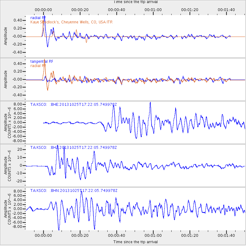
Earthquake location: Off East Coast Of Honshu, Japan
Earthquake latitude/longitude: 37.2/144.7
Earthquake time(UTC): 2013/10/25 (298) 17:10:19 GMT
Earthquake Depth: 35 km
Earthquake Magnitude: 7.1 MWW, 7.1 MWW, 7.1 MWB, 7.1 MWC, 7.2 MWC, 7.5 MI
Earthquake Catalog/Contributor: NEIC PDE/NEIC COMCAT
Network: TA USArray Transportable Network (new EarthScope stations)
Station: KSCO Kaye Shedlock's, Cheyenne Wells, CO, USA
Lat/Lon: 39.01 N/102.63 W
Elevation: 1382 m
Distance: 82.1 deg
Az: 46.509 deg
Baz: 311.929 deg
Ray Param: 0.047044024
Estimated Moho Depth: 37.75 km
Estimated Crust Vp/Vs: 1.89
Assumed Crust Vp: 6.242 km/s
Estimated Crust Vs: 3.307 km/s
Estimated Crust Poisson's Ratio: 0.30
Radial Match: 97.56099 %
Radial Bump: 369
Transverse Match: 91.58273 %
Transverse Bump: 400
SOD ConfigId: 626651
Insert Time: 2014-04-19 06:11:02.237 +0000
GWidth: 2.5
Max Bumps: 400
Tol: 0.001

Signal To Noise

ChannelStoNSTALTA
TA:KSCO: :BHZ:20131025T17:22:05.749978Z27.6356624.528605E-61.6386817E-7
TA:KSCO: :BHN:20131025T17:22:05.749978Z3.93824931.5028187E-63.815956E-7
TA:KSCO: :BHE:20131025T17:22:05.749978Z7.0871771.6822057E-62.3735907E-7
Arrivals
Ps5.5 SECOND
PpPs17 SECOND
PsPs/PpSs23 SECOND