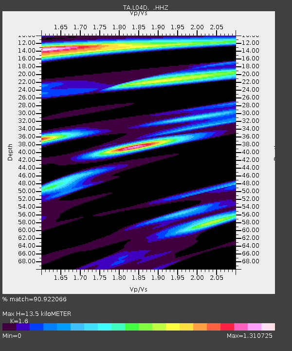
L04D Klamath Falls, OR, USA - Earthquake Result Viewer
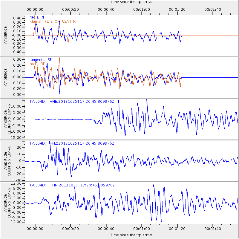
Earthquake location: Off East Coast Of Honshu, Japan
Earthquake latitude/longitude: 37.2/144.7
Earthquake time(UTC): 2013/10/25 (298) 17:10:19 GMT
Earthquake Depth: 35 km
Earthquake Magnitude: 7.1 MWW, 7.1 MWW, 7.1 MWB, 7.1 MWC, 7.2 MWC, 7.5 MI
Earthquake Catalog/Contributor: NEIC PDE/NEIC COMCAT
Network: TA USArray Transportable Network (new EarthScope stations)
Station: L04D Klamath Falls, OR, USA
Lat/Lon: 42.22 N/122.30 W
Elevation: 1437 m
Distance: 68.2 deg
Az: 53.023 deg
Baz: 300.771 deg
Ray Param: 0.05639762
Estimated Moho Depth: 13.5 km
Estimated Crust Vp/Vs: 1.60
Assumed Crust Vp: 6.522 km/s
Estimated Crust Vs: 4.076 km/s
Estimated Crust Poisson's Ratio: 0.18
Radial Match: 90.922066 %
Radial Bump: 400
Transverse Match: 86.7853 %
Transverse Bump: 375
SOD ConfigId: 626651
Insert Time: 2014-04-19 06:11:08.005 +0000
GWidth: 2.5
Max Bumps: 400
Tol: 0.001

Signal To Noise

ChannelStoNSTALTA
TA:L04D: :HHZ:20131025T17:20:45.809976Z23.5980745.4330394E-62.3023233E-7
TA:L04D: :HHN:20131025T17:20:45.809976Z4.51007751.1404219E-62.5286081E-7
TA:L04D: :HHE:20131025T17:20:45.809976Z6.15047451.2735629E-62.0706743E-7
Arrivals
Ps1.3 SECOND
PpPs5.1 SECOND
PsPs/PpSs6.4 SECOND