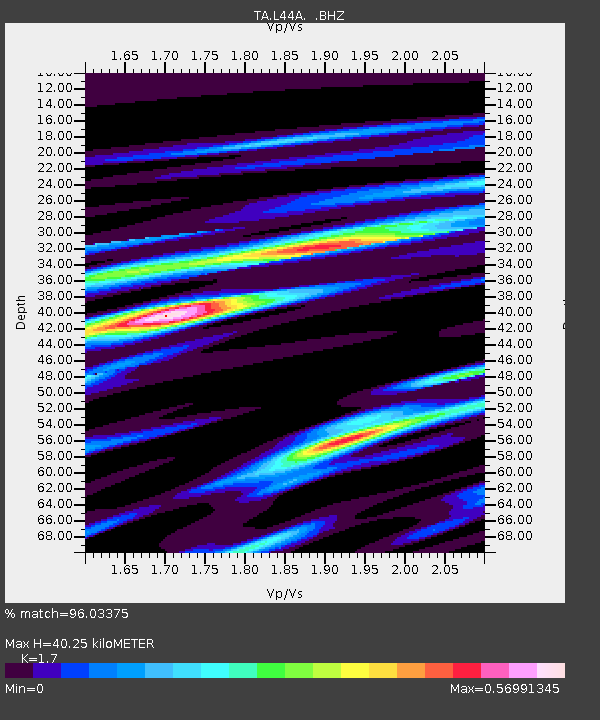
L44A Lake County Forest Preserve, Grayslake, IL, USA - Earthquake Result Viewer

Earthquake location: Off East Coast Of Honshu, Japan
Earthquake latitude/longitude: 37.2/144.7
Earthquake time(UTC): 2013/10/25 (298) 17:10:19 GMT
Earthquake Depth: 35 km
Earthquake Magnitude: 7.1 MWW, 7.1 MWW, 7.1 MWB, 7.1 MWC, 7.2 MWC, 7.5 MI
Earthquake Catalog/Contributor: NEIC PDE/NEIC COMCAT
Network: TA USArray Transportable Network (new EarthScope stations)
Station: L44A Lake County Forest Preserve, Grayslake, IL, USA
Lat/Lon: 42.18 N/87.91 W
Elevation: 202 m
Distance: 87.6 deg
Az: 36.212 deg
Baz: 320.579 deg
Ray Param: 0.043142356
Estimated Moho Depth: 40.25 km
Estimated Crust Vp/Vs: 1.70
Assumed Crust Vp: 6.483 km/s
Estimated Crust Vs: 3.813 km/s
Estimated Crust Poisson's Ratio: 0.24
Radial Match: 96.03375 %
Radial Bump: 400
Transverse Match: 80.05201 %
Transverse Bump: 400
SOD ConfigId: 626651
Insert Time: 2014-04-19 06:11:13.575 +0000
GWidth: 2.5
Max Bumps: 400
Tol: 0.001

Signal To Noise

ChannelStoNSTALTA
TA:L44A: :BHZ:20131025T17:22:33.19999Z11.8082995.065994E-64.2901982E-7
TA:L44A: :BHN:20131025T17:22:33.19999Z2.65812281.5512684E-65.8359547E-7
TA:L44A: :BHE:20131025T17:22:33.19999Z3.04030681.3266003E-64.3633761E-7
Arrivals
Ps4.5 SECOND
PpPs16 SECOND
PsPs/PpSs21 SECOND