L48A N Adams, MI, USA - Earthquake Result Viewer
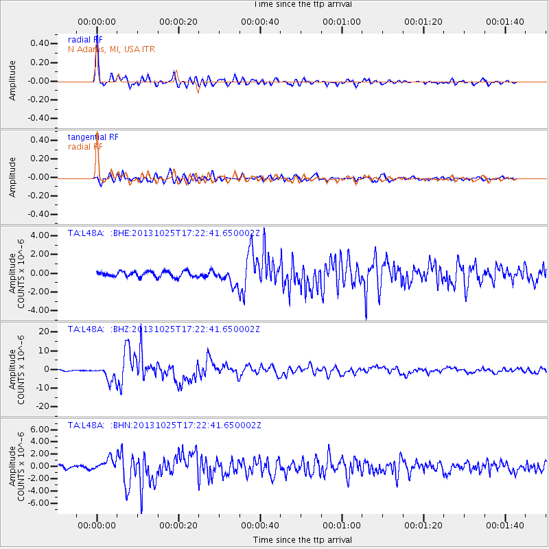
Earthquake location: Off East Coast Of Honshu, Japan
Earthquake latitude/longitude: 37.2/144.7
Earthquake time(UTC): 2013/10/25 (298) 17:10:19 GMT
Earthquake Depth: 35 km
Earthquake Magnitude: 7.1 MWW, 7.1 MWW, 7.1 MWB, 7.1 MWC, 7.2 MWC, 7.5 MI
Earthquake Catalog/Contributor: NEIC PDE/NEIC COMCAT
Network: TA USArray Transportable Network (new EarthScope stations)
Station: L48A N Adams, MI, USA
Lat/Lon: 41.94 N/84.43 W
Elevation: 369 m
Distance: 89.4 deg
Az: 34.324 deg
Baz: 322.853 deg
Ray Param: 0.04182148
Estimated Moho Depth: 25.5 km
Estimated Crust Vp/Vs: 1.90
Assumed Crust Vp: 6.498 km/s
Estimated Crust Vs: 3.411 km/s
Estimated Crust Poisson's Ratio: 0.31
Radial Match: 94.95786 %
Radial Bump: 382
Transverse Match: 93.153534 %
Transverse Bump: 400
SOD ConfigId: 626651
Insert Time: 2014-04-19 06:11:18.238 +0000
GWidth: 2.5
Max Bumps: 400
Tol: 0.001

Signal To Noise

ChannelStoNSTALTA
TA:L48A: :BHZ:20131025T17:22:41.650002Z13.9860944.183869E-62.991449E-7
TA:L48A: :BHN:20131025T17:22:41.650002Z3.8733321.0392772E-62.683161E-7
TA:L48A: :BHE:20131025T17:22:41.650002Z3.15119179.0961504E-72.8865747E-7
Arrivals
Ps3.6 SECOND
PpPs11 SECOND
PsPs/PpSs15 SECOND