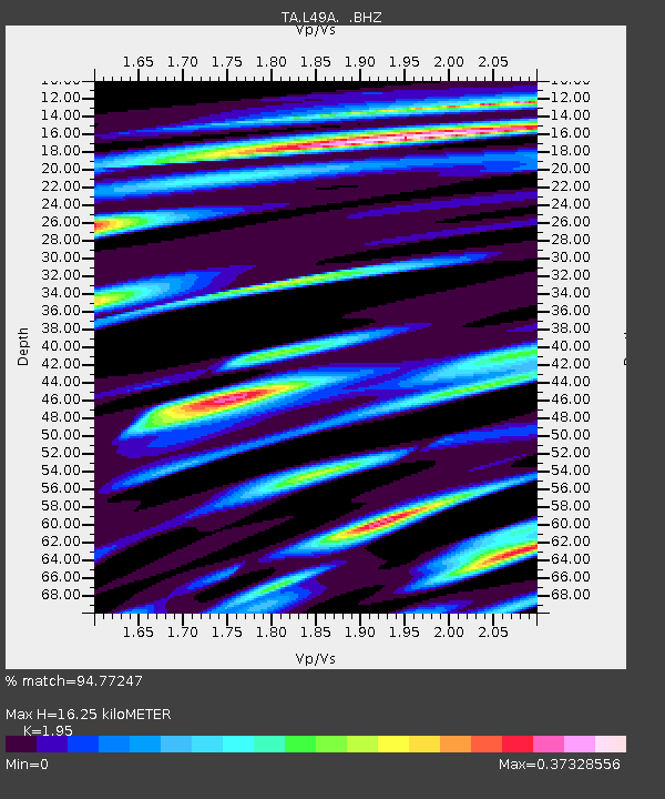
L49A Milan, MI, USA - Earthquake Result Viewer
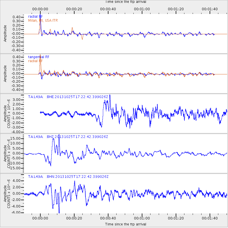
Earthquake location: Off East Coast Of Honshu, Japan
Earthquake latitude/longitude: 37.2/144.7
Earthquake time(UTC): 2013/10/25 (298) 17:10:19 GMT
Earthquake Depth: 35 km
Earthquake Magnitude: 7.1 MWW, 7.1 MWW, 7.1 MWB, 7.1 MWC, 7.2 MWC, 7.5 MI
Earthquake Catalog/Contributor: NEIC PDE/NEIC COMCAT
Network: TA USArray Transportable Network (new EarthScope stations)
Station: L49A Milan, MI, USA
Lat/Lon: 42.11 N/83.77 W
Elevation: 230 m
Distance: 89.6 deg
Az: 33.828 deg
Baz: 323.293 deg
Ray Param: 0.041730057
Estimated Moho Depth: 16.25 km
Estimated Crust Vp/Vs: 1.95
Assumed Crust Vp: 6.483 km/s
Estimated Crust Vs: 3.324 km/s
Estimated Crust Poisson's Ratio: 0.32
Radial Match: 94.77247 %
Radial Bump: 378
Transverse Match: 89.82461 %
Transverse Bump: 400
SOD ConfigId: 626651
Insert Time: 2014-04-19 06:11:21.246 +0000
GWidth: 2.5
Max Bumps: 400
Tol: 0.001

Signal To Noise

ChannelStoNSTALTA
TA:L49A: :BHZ:20131025T17:22:42.399026Z11.84443.3744182E-62.8489563E-7
TA:L49A: :BHN:20131025T17:22:42.399026Z3.86159131.0385326E-62.68939E-7
TA:L49A: :BHE:20131025T17:22:42.399026Z2.24387346.7248135E-72.9969667E-7
Arrivals
Ps2.4 SECOND
PpPs7.3 SECOND
PsPs/PpSs9.7 SECOND