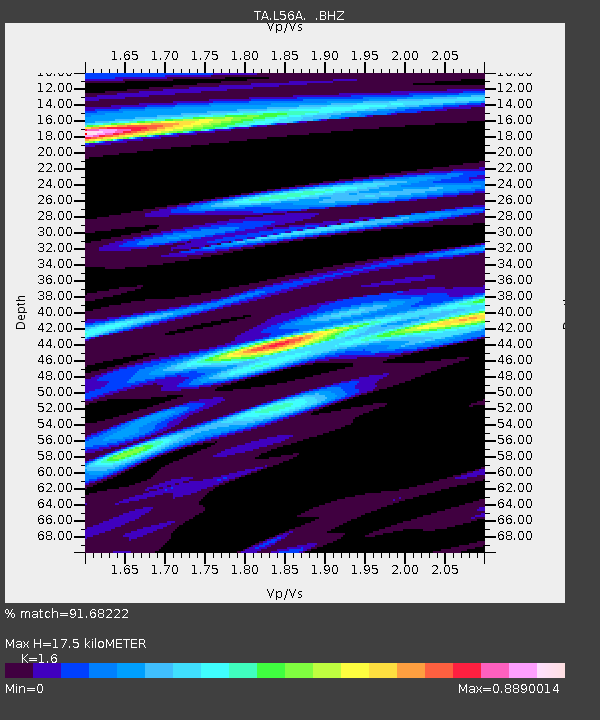
L56A Greenwood, NY, USA - Earthquake Result Viewer
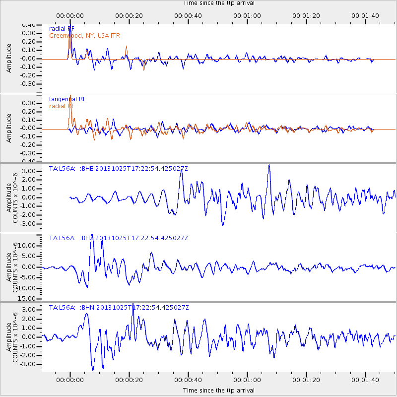
Earthquake location: Off East Coast Of Honshu, Japan
Earthquake latitude/longitude: 37.2/144.7
Earthquake time(UTC): 2013/10/25 (298) 17:10:19 GMT
Earthquake Depth: 35 km
Earthquake Magnitude: 7.1 MWW, 7.1 MWW, 7.1 MWB, 7.1 MWC, 7.2 MWC, 7.5 MI
Earthquake Catalog/Contributor: NEIC PDE/NEIC COMCAT
Network: TA USArray Transportable Network (new EarthScope stations)
Station: L56A Greenwood, NY, USA
Lat/Lon: 42.14 N/77.56 W
Elevation: 688 m
Distance: 92.2 deg
Az: 30.011 deg
Baz: 327.502 deg
Ray Param: 0.041487683
Estimated Moho Depth: 17.5 km
Estimated Crust Vp/Vs: 1.60
Assumed Crust Vp: 6.476 km/s
Estimated Crust Vs: 4.047 km/s
Estimated Crust Poisson's Ratio: 0.18
Radial Match: 91.68222 %
Radial Bump: 400
Transverse Match: 78.766846 %
Transverse Bump: 400
SOD ConfigId: 626651
Insert Time: 2014-04-19 06:11:33.267 +0000
GWidth: 2.5
Max Bumps: 400
Tol: 0.001

Signal To Noise

ChannelStoNSTALTA
TA:L56A: :BHZ:20131025T17:22:54.425027Z7.60697563.2154737E-64.2270068E-7
TA:L56A: :BHN:20131025T17:22:54.425027Z2.48910248.198277E-73.293668E-7
TA:L56A: :BHE:20131025T17:22:54.425027Z3.02859331.0018474E-63.3079627E-7
Arrivals
Ps1.7 SECOND
PpPs6.9 SECOND
PsPs/PpSs8.5 SECOND