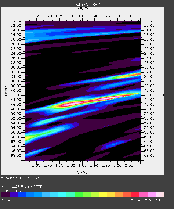
L58A Harry Jones Memorial, Binghamton, NY, USA - Earthquake Result Viewer
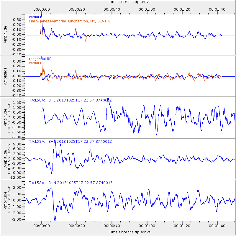
Earthquake location: Off East Coast Of Honshu, Japan
Earthquake latitude/longitude: 37.2/144.7
Earthquake time(UTC): 2013/10/25 (298) 17:10:19 GMT
Earthquake Depth: 35 km
Earthquake Magnitude: 7.1 MWW, 7.1 MWW, 7.1 MWB, 7.1 MWC, 7.2 MWC, 7.5 MI
Earthquake Catalog/Contributor: NEIC PDE/NEIC COMCAT
Network: TA USArray Transportable Network (new EarthScope stations)
Station: L58A Harry Jones Memorial, Binghamton, NY, USA
Lat/Lon: 42.04 N/75.85 W
Elevation: 447 m
Distance: 92.9 deg
Az: 28.979 deg
Baz: 328.69 deg
Ray Param: 0.041348692
Estimated Moho Depth: 45.5 km
Estimated Crust Vp/Vs: 1.81
Assumed Crust Vp: 6.419 km/s
Estimated Crust Vs: 3.551 km/s
Estimated Crust Poisson's Ratio: 0.28
Radial Match: 83.253174 %
Radial Bump: 292
Transverse Match: 71.56421 %
Transverse Bump: 400
SOD ConfigId: 626651
Insert Time: 2014-04-19 06:11:38.519 +0000
GWidth: 2.5
Max Bumps: 400
Tol: 0.001

Signal To Noise

ChannelStoNSTALTA
TA:L58A: :BHZ:20131025T17:22:57.874001Z3.7401762.6602106E-67.1125277E-7
TA:L58A: :BHN:20131025T17:22:57.874001Z2.22773159.972855E-74.476686E-7
TA:L58A: :BHE:20131025T17:22:57.874001Z1.76809177.605044E-74.3012724E-7
Arrivals
Ps5.8 SECOND
PpPs20 SECOND
PsPs/PpSs25 SECOND