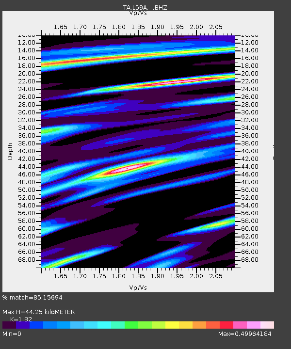
L59A Walton, NY, USA - Earthquake Result Viewer
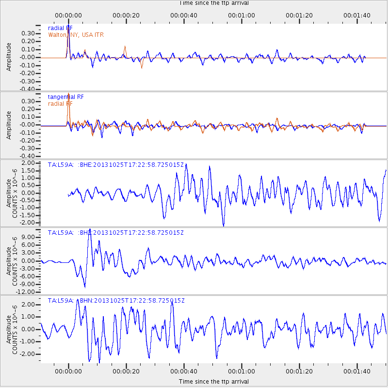
Earthquake location: Off East Coast Of Honshu, Japan
Earthquake latitude/longitude: 37.2/144.7
Earthquake time(UTC): 2013/10/25 (298) 17:10:19 GMT
Earthquake Depth: 35 km
Earthquake Magnitude: 7.1 MWW, 7.1 MWW, 7.1 MWB, 7.1 MWC, 7.2 MWC, 7.5 MI
Earthquake Catalog/Contributor: NEIC PDE/NEIC COMCAT
Network: TA USArray Transportable Network (new EarthScope stations)
Station: L59A Walton, NY, USA
Lat/Lon: 42.19 N/75.04 W
Elevation: 677 m
Distance: 93.1 deg
Az: 28.388 deg
Baz: 329.26 deg
Ray Param: 0.0413121
Estimated Moho Depth: 44.25 km
Estimated Crust Vp/Vs: 1.82
Assumed Crust Vp: 6.419 km/s
Estimated Crust Vs: 3.527 km/s
Estimated Crust Poisson's Ratio: 0.28
Radial Match: 85.15694 %
Radial Bump: 391
Transverse Match: 86.732086 %
Transverse Bump: 400
SOD ConfigId: 626651
Insert Time: 2014-04-19 06:11:40.989 +0000
GWidth: 2.5
Max Bumps: 400
Tol: 0.001

Signal To Noise

ChannelStoNSTALTA
TA:L59A: :BHZ:20131025T17:22:58.725015Z8.930372.823735E-63.161946E-7
TA:L59A: :BHN:20131025T17:22:58.725015Z3.11156151.1546043E-63.710691E-7
TA:L59A: :BHE:20131025T17:22:58.725015Z3.34290557.6175576E-72.2787235E-7
Arrivals
Ps5.8 SECOND
PpPs19 SECOND
PsPs/PpSs25 SECOND