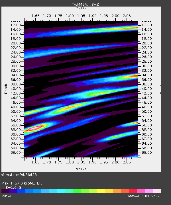
M49A Liberty Center, OH, USA - Earthquake Result Viewer
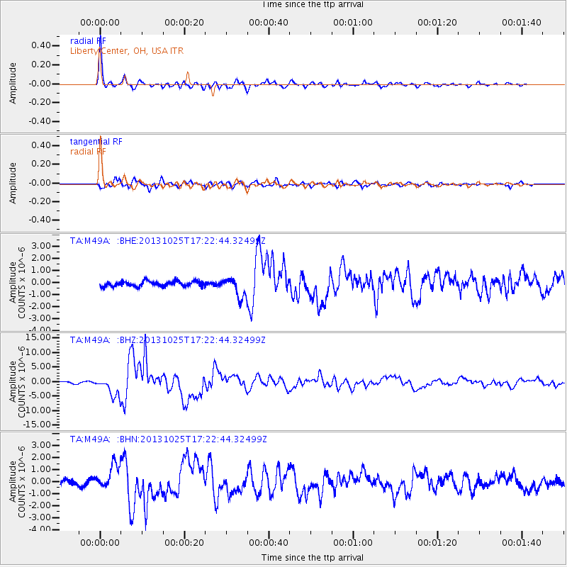
Earthquake location: Off East Coast Of Honshu, Japan
Earthquake latitude/longitude: 37.2/144.7
Earthquake time(UTC): 2013/10/25 (298) 17:10:19 GMT
Earthquake Depth: 35 km
Earthquake Magnitude: 7.1 MWW, 7.1 MWW, 7.1 MWB, 7.1 MWC, 7.2 MWC, 7.5 MI
Earthquake Catalog/Contributor: NEIC PDE/NEIC COMCAT
Network: TA USArray Transportable Network (new EarthScope stations)
Station: M49A Liberty Center, OH, USA
Lat/Lon: 41.47 N/83.98 W
Elevation: 203 m
Distance: 90.0 deg
Az: 34.332 deg
Baz: 323.156 deg
Ray Param: 0.041700494
Estimated Moho Depth: 57.0 km
Estimated Crust Vp/Vs: 1.64
Assumed Crust Vp: 6.498 km/s
Estimated Crust Vs: 3.95 km/s
Estimated Crust Poisson's Ratio: 0.21
Radial Match: 96.86648 %
Radial Bump: 376
Transverse Match: 86.14434 %
Transverse Bump: 400
SOD ConfigId: 626651
Insert Time: 2014-04-19 06:12:12.945 +0000
GWidth: 2.5
Max Bumps: 400
Tol: 0.001

Signal To Noise

ChannelStoNSTALTA
TA:M49A: :BHZ:20131025T17:22:44.32499Z13.2350833.455507E-62.6108694E-7
TA:M49A: :BHN:20131025T17:22:44.32499Z4.4669981.0653921E-62.3850293E-7
TA:M49A: :BHE:20131025T17:22:44.32499Z3.84893018.5298313E-72.2161565E-7
Arrivals
Ps5.8 SECOND
PpPs23 SECOND
PsPs/PpSs28 SECOND