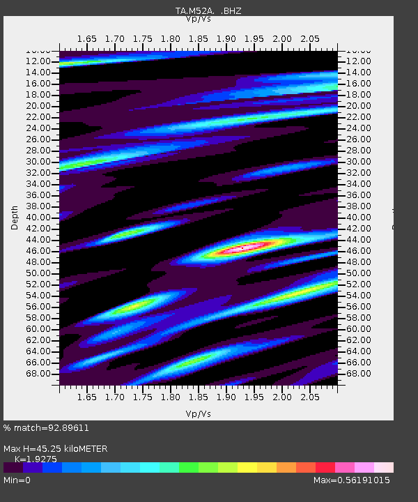
M52A Chesterland, OH, USA - Earthquake Result Viewer
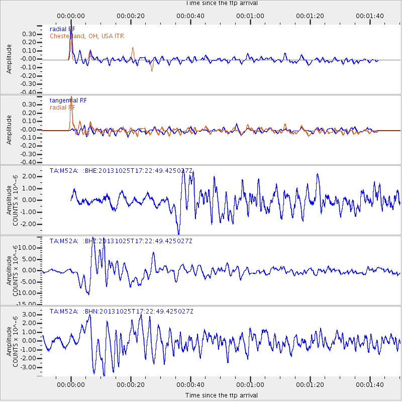
Earthquake location: Off East Coast Of Honshu, Japan
Earthquake latitude/longitude: 37.2/144.7
Earthquake time(UTC): 2013/10/25 (298) 17:10:19 GMT
Earthquake Depth: 35 km
Earthquake Magnitude: 7.1 MWW, 7.1 MWW, 7.1 MWB, 7.1 MWC, 7.2 MWC, 7.5 MI
Earthquake Catalog/Contributor: NEIC PDE/NEIC COMCAT
Network: TA USArray Transportable Network (new EarthScope stations)
Station: M52A Chesterland, OH, USA
Lat/Lon: 41.54 N/81.36 W
Elevation: 382 m
Distance: 91.1 deg
Az: 32.702 deg
Baz: 324.901 deg
Ray Param: 0.041621923
Estimated Moho Depth: 45.25 km
Estimated Crust Vp/Vs: 1.93
Assumed Crust Vp: 6.483 km/s
Estimated Crust Vs: 3.363 km/s
Estimated Crust Poisson's Ratio: 0.32
Radial Match: 92.89611 %
Radial Bump: 400
Transverse Match: 77.218124 %
Transverse Bump: 400
SOD ConfigId: 626651
Insert Time: 2014-04-19 06:12:22.366 +0000
GWidth: 2.5
Max Bumps: 400
Tol: 0.001

Signal To Noise

ChannelStoNSTALTA
TA:M52A: :BHZ:20131025T17:22:49.425027Z8.6391093.2774801E-63.793771E-7
TA:M52A: :BHN:20131025T17:22:49.425027Z2.0604119.2633763E-74.4958875E-7
TA:M52A: :BHE:20131025T17:22:49.425027Z1.31568834.661276E-73.5428423E-7
Arrivals
Ps6.6 SECOND
PpPs20 SECOND
PsPs/PpSs27 SECOND