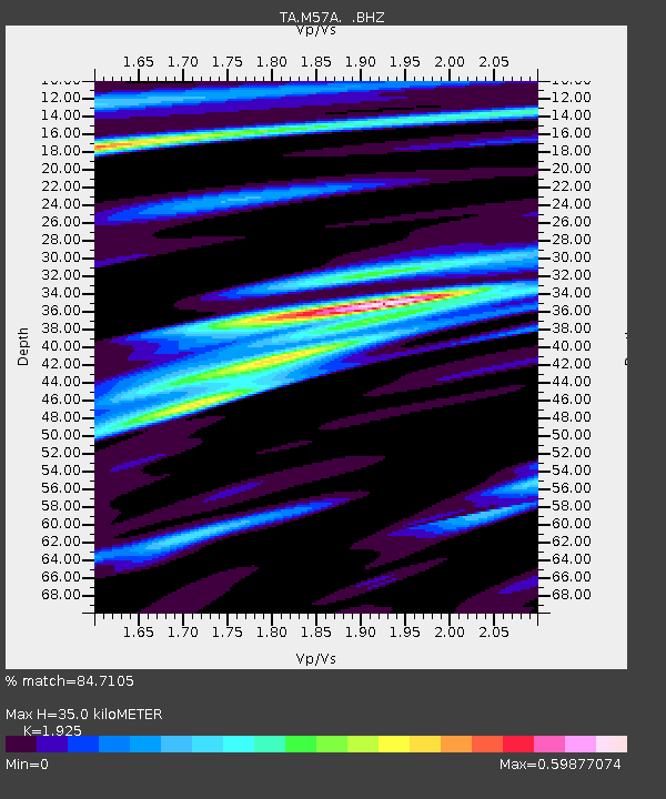
M57A Sunshine Farm, Cogan Station, PA, USA - Earthquake Result Viewer
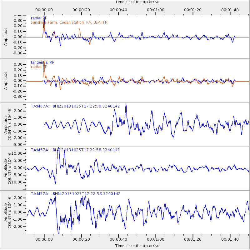
Earthquake location: Off East Coast Of Honshu, Japan
Earthquake latitude/longitude: 37.2/144.7
Earthquake time(UTC): 2013/10/25 (298) 17:10:19 GMT
Earthquake Depth: 35 km
Earthquake Magnitude: 7.1 MWW, 7.1 MWW, 7.1 MWB, 7.1 MWC, 7.2 MWC, 7.5 MI
Earthquake Catalog/Contributor: NEIC PDE/NEIC COMCAT
Network: TA USArray Transportable Network (new EarthScope stations)
Station: M57A Sunshine Farm, Cogan Station, PA, USA
Lat/Lon: 41.34 N/77.13 W
Elevation: 319 m
Distance: 93.0 deg
Az: 30.167 deg
Baz: 327.781 deg
Ray Param: 0.04132947
Estimated Moho Depth: 35.0 km
Estimated Crust Vp/Vs: 1.92
Assumed Crust Vp: 6.121 km/s
Estimated Crust Vs: 3.179 km/s
Estimated Crust Poisson's Ratio: 0.32
Radial Match: 84.7105 %
Radial Bump: 400
Transverse Match: 72.60099 %
Transverse Bump: 400
SOD ConfigId: 626651
Insert Time: 2014-04-19 06:12:33.514 +0000
GWidth: 2.5
Max Bumps: 400
Tol: 0.001

Signal To Noise

ChannelStoNSTALTA
TA:M57A: :BHZ:20131025T17:22:58.324014Z5.83913042.825926E-64.839635E-7
TA:M57A: :BHN:20131025T17:22:58.324014Z2.95138071.0436098E-63.5360054E-7
TA:M57A: :BHE:20131025T17:22:58.324014Z1.36057476.746424E-74.9585105E-7
Arrivals
Ps5.4 SECOND
PpPs16 SECOND
PsPs/PpSs22 SECOND