You are here: Home > Network List > TA - USArray Transportable Network (new EarthScope stations) Stations List
> Station M63A Gales Ferry, CT, USA > Earthquake Result Viewer
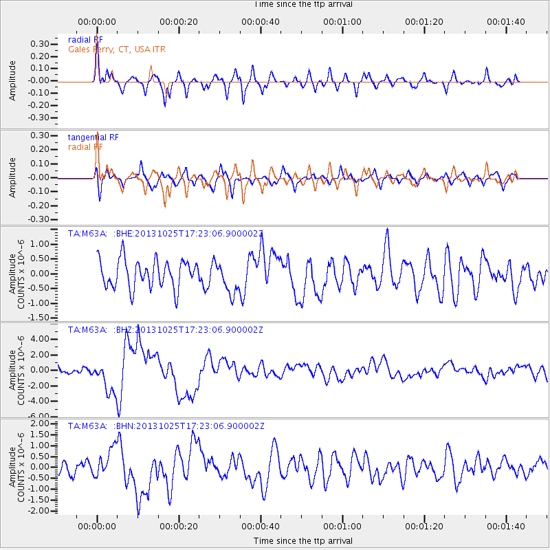
M63A Gales Ferry, CT, USA - Earthquake Result Viewer
*The percent match for this event was below the threshold and hence no stack was calculated.
| Earthquake location: |
Off East Coast Of Honshu, Japan |
| Earthquake latitude/longitude: |
37.2/144.7 |
| Earthquake time(UTC): |
2013/10/25 (298) 17:10:19 GMT |
| Earthquake Depth: |
35 km |
| Earthquake Magnitude: |
7.1 MWW, 7.1 MWW, 7.1 MWB, 7.1 MWC, 7.2 MWC, 7.5 MI |
| Earthquake Catalog/Contributor: |
NEIC PDE/NEIC COMCAT |
|
| Network: |
TA USArray Transportable Network (new EarthScope stations) |
| Station: |
M63A Gales Ferry, CT, USA |
| Lat/Lon: |
41.40 N/72.05 W |
| Elevation: |
44 m |
|
| Distance: |
94.9 deg |
| Az: |
26.828 deg |
| Baz: |
331.36 deg |
| Ray Param: |
$rayparam |
*The percent match for this event was below the threshold and hence was not used in the summary stack. |
|
| Radial Match: |
76.108345 % |
| Radial Bump: |
400 |
| Transverse Match: |
63.734077 % |
| Transverse Bump: |
400 |
| SOD ConfigId: |
626651 |
| Insert Time: |
2014-04-19 06:12:48.697 +0000 |
| GWidth: |
2.5 |
| Max Bumps: |
400 |
| Tol: |
0.001 |
|
Signal To Noise
| Channel | StoN | STA | LTA |
| TA:M63A: :BHZ:20131025T17:23:06.900002Z | 4.244805 | 2.1225062E-6 | 5.0002444E-7 |
| TA:M63A: :BHN:20131025T17:23:06.900002Z | 1.6956985 | 6.7825465E-7 | 3.999854E-7 |
| TA:M63A: :BHE:20131025T17:23:06.900002Z | 1.1537191 | 5.436265E-7 | 4.7119485E-7 |
| Arrivals |
| Ps | |
| PpPs | |
| PsPs/PpSs | |


