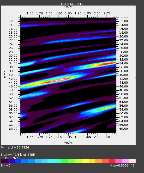
MSTX Muleshoe, TX, USA - Earthquake Result Viewer
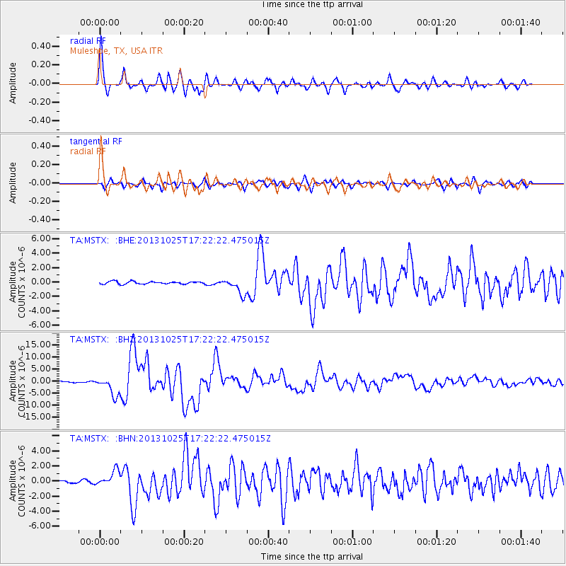
Earthquake location: Off East Coast Of Honshu, Japan
Earthquake latitude/longitude: 37.2/144.7
Earthquake time(UTC): 2013/10/25 (298) 17:10:19 GMT
Earthquake Depth: 35 km
Earthquake Magnitude: 7.1 MWW, 7.1 MWW, 7.1 MWB, 7.1 MWC, 7.2 MWC, 7.5 MI
Earthquake Catalog/Contributor: NEIC PDE/NEIC COMCAT
Network: TA USArray Transportable Network (new EarthScope stations)
Station: MSTX Muleshoe, TX, USA
Lat/Lon: 33.97 N/102.77 W
Elevation: 1167 m
Distance: 85.4 deg
Az: 50.343 deg
Baz: 312.258 deg
Ray Param: 0.044723105
Estimated Moho Depth: 42.5 km
Estimated Crust Vp/Vs: 1.80
Assumed Crust Vp: 6.129 km/s
Estimated Crust Vs: 3.41 km/s
Estimated Crust Poisson's Ratio: 0.28
Radial Match: 95.9826 %
Radial Bump: 400
Transverse Match: 89.84689 %
Transverse Bump: 400
SOD ConfigId: 626651
Insert Time: 2014-04-19 06:13:02.212 +0000
GWidth: 2.5
Max Bumps: 400
Tol: 0.001

Signal To Noise

ChannelStoNSTALTA
TA:MSTX: :BHZ:20131025T17:22:22.475015Z13.2170174.028369E-63.0478654E-7
TA:MSTX: :BHN:20131025T17:22:22.475015Z4.85790161.0783913E-62.2198705E-7
TA:MSTX: :BHE:20131025T17:22:22.475015Z6.5211861.14706E-61.7589744E-7
Arrivals
Ps5.6 SECOND
PpPs19 SECOND
PsPs/PpSs25 SECOND