N02D Trinity Center, CA, USA - Earthquake Result Viewer
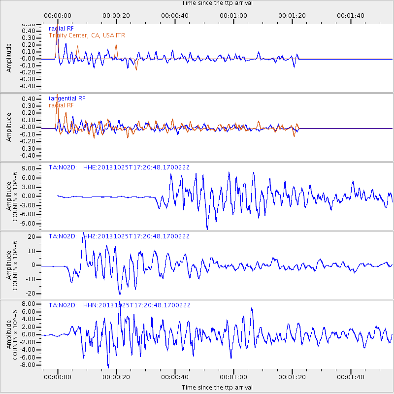
Earthquake location: Off East Coast Of Honshu, Japan
Earthquake latitude/longitude: 37.2/144.7
Earthquake time(UTC): 2013/10/25 (298) 17:10:19 GMT
Earthquake Depth: 35 km
Earthquake Magnitude: 7.1 MWW, 7.1 MWW, 7.1 MWB, 7.1 MWC, 7.2 MWC, 7.5 MI
Earthquake Catalog/Contributor: NEIC PDE/NEIC COMCAT
Network: TA USArray Transportable Network (new EarthScope stations)
Station: N02D Trinity Center, CA, USA
Lat/Lon: 40.97 N/122.71 W
Elevation: 937 m
Distance: 68.6 deg
Az: 54.336 deg
Baz: 300.99 deg
Ray Param: 0.05614914
Estimated Moho Depth: 24.0 km
Estimated Crust Vp/Vs: 1.76
Assumed Crust Vp: 6.566 km/s
Estimated Crust Vs: 3.736 km/s
Estimated Crust Poisson's Ratio: 0.26
Radial Match: 93.6178 %
Radial Bump: 400
Transverse Match: 89.68263 %
Transverse Bump: 400
SOD ConfigId: 626651
Insert Time: 2014-04-19 06:13:05.986 +0000
GWidth: 2.5
Max Bumps: 400
Tol: 0.001

Signal To Noise

ChannelStoNSTALTA
TA:N02D: :HHZ:20131025T17:20:48.170022Z22.0603643.951395E-61.7911738E-7
TA:N02D: :HHN:20131025T17:20:48.170022Z6.045516.5013495E-71.0754014E-7
TA:N02D: :HHE:20131025T17:20:48.170022Z9.9595331.270292E-61.2754535E-7
Arrivals
Ps2.9 SECOND
PpPs9.7 SECOND
PsPs/PpSs13 SECOND