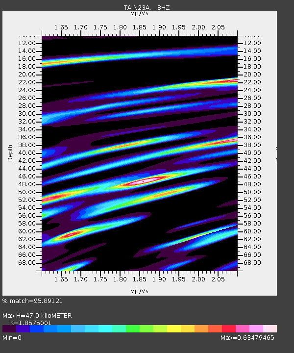
N23A Red Feather Lakes, CO, USA - Earthquake Result Viewer
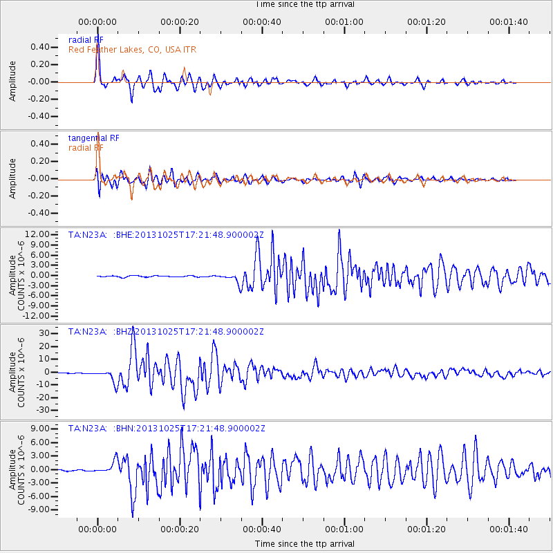
Earthquake location: Off East Coast Of Honshu, Japan
Earthquake latitude/longitude: 37.2/144.7
Earthquake time(UTC): 2013/10/25 (298) 17:10:19 GMT
Earthquake Depth: 35 km
Earthquake Magnitude: 7.1 MWW, 7.1 MWW, 7.1 MWB, 7.1 MWC, 7.2 MWC, 7.5 MI
Earthquake Catalog/Contributor: NEIC PDE/NEIC COMCAT
Network: TA USArray Transportable Network (new EarthScope stations)
Station: N23A Red Feather Lakes, CO, USA
Lat/Lon: 40.89 N/105.94 W
Elevation: 2458 m
Distance: 79.0 deg
Az: 46.76 deg
Baz: 309.848 deg
Ray Param: 0.04922201
Estimated Moho Depth: 47.0 km
Estimated Crust Vp/Vs: 1.86
Assumed Crust Vp: 6.306 km/s
Estimated Crust Vs: 3.395 km/s
Estimated Crust Poisson's Ratio: 0.30
Radial Match: 95.89121 %
Radial Bump: 400
Transverse Match: 90.50936 %
Transverse Bump: 400
SOD ConfigId: 626651
Insert Time: 2014-04-19 06:13:06.833 +0000
GWidth: 2.5
Max Bumps: 400
Tol: 0.001

Signal To Noise

ChannelStoNSTALTA
TA:N23A: :BHZ:20131025T17:21:48.900002Z40.2081155.4057023E-61.3444307E-7
TA:N23A: :BHN:20131025T17:21:48.900002Z6.69600151.5017856E-62.2428094E-7
TA:N23A: :BHE:20131025T17:21:48.900002Z7.99836161.43365E-61.7924296E-7
Arrivals
Ps6.6 SECOND
PpPs21 SECOND
PsPs/PpSs27 SECOND