N50A Nevada, OH, USA - Earthquake Result Viewer
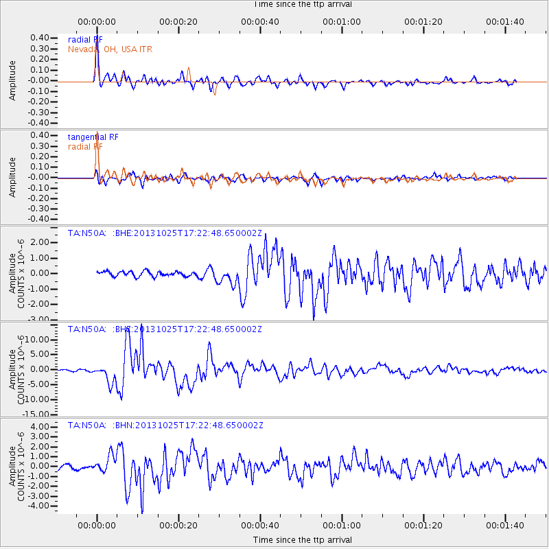
Earthquake location: Off East Coast Of Honshu, Japan
Earthquake latitude/longitude: 37.2/144.7
Earthquake time(UTC): 2013/10/25 (298) 17:10:19 GMT
Earthquake Depth: 35 km
Earthquake Magnitude: 7.1 MWW, 7.1 MWW, 7.1 MWB, 7.1 MWC, 7.2 MWC, 7.5 MI
Earthquake Catalog/Contributor: NEIC PDE/NEIC COMCAT
Network: TA USArray Transportable Network (new EarthScope stations)
Station: N50A Nevada, OH, USA
Lat/Lon: 40.77 N/83.15 W
Elevation: 277 m
Distance: 90.9 deg
Az: 34.249 deg
Baz: 323.699 deg
Ray Param: 0.041633707
Estimated Moho Depth: 14.25 km
Estimated Crust Vp/Vs: 2.10
Assumed Crust Vp: 6.498 km/s
Estimated Crust Vs: 3.098 km/s
Estimated Crust Poisson's Ratio: 0.35
Radial Match: 95.130875 %
Radial Bump: 392
Transverse Match: 86.94413 %
Transverse Bump: 400
SOD ConfigId: 626651
Insert Time: 2014-04-19 06:13:22.925 +0000
GWidth: 2.5
Max Bumps: 400
Tol: 0.001

Signal To Noise

ChannelStoNSTALTA
TA:N50A: :BHZ:20131025T17:22:48.650002Z9.1280243.1168497E-63.4145938E-7
TA:N50A: :BHN:20131025T17:22:48.650002Z2.97059688.649936E-72.9118513E-7
TA:N50A: :BHE:20131025T17:22:48.650002Z3.33973745.301411E-71.5873736E-7
Arrivals
Ps2.5 SECOND
PpPs6.7 SECOND
PsPs/PpSs9.1 SECOND