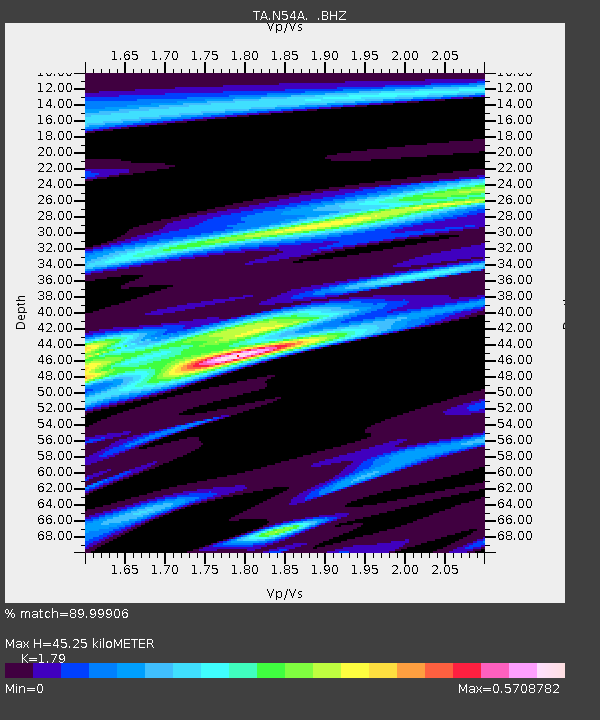
N54A Moraine State Park, Portersville, PA, USA - Earthquake Result Viewer
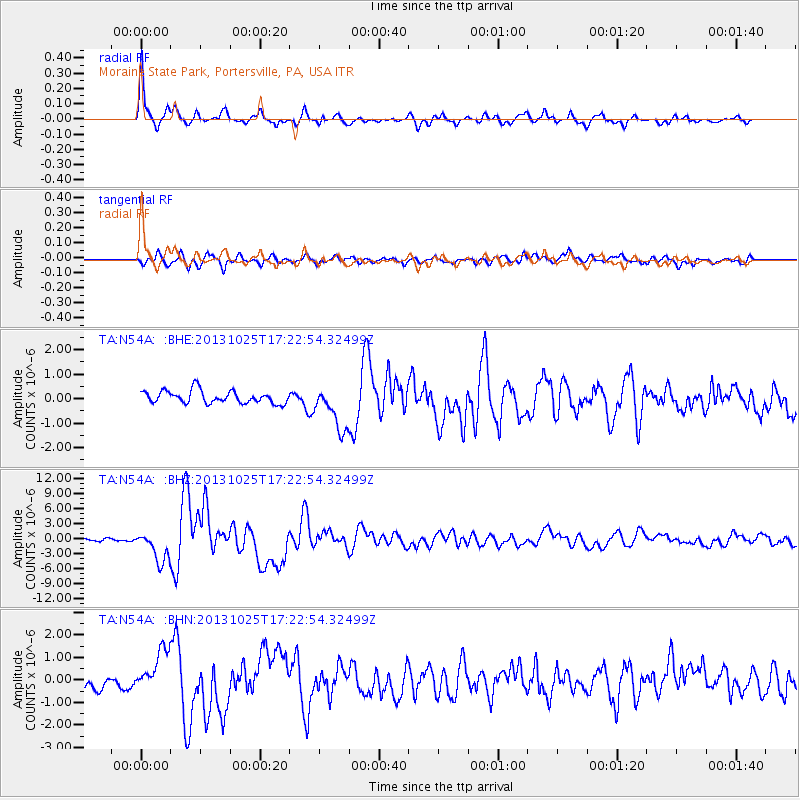
Earthquake location: Off East Coast Of Honshu, Japan
Earthquake latitude/longitude: 37.2/144.7
Earthquake time(UTC): 2013/10/25 (298) 17:10:19 GMT
Earthquake Depth: 35 km
Earthquake Magnitude: 7.1 MWW, 7.1 MWW, 7.1 MWB, 7.1 MWC, 7.2 MWC, 7.5 MI
Earthquake Catalog/Contributor: NEIC PDE/NEIC COMCAT
Network: TA USArray Transportable Network (new EarthScope stations)
Station: N54A Moraine State Park, Portersville, PA, USA
Lat/Lon: 40.96 N/79.99 W
Elevation: 408 m
Distance: 92.2 deg
Az: 32.182 deg
Baz: 325.814 deg
Ray Param: 0.04149103
Estimated Moho Depth: 45.25 km
Estimated Crust Vp/Vs: 1.79
Assumed Crust Vp: 6.121 km/s
Estimated Crust Vs: 3.419 km/s
Estimated Crust Poisson's Ratio: 0.27
Radial Match: 89.99906 %
Radial Bump: 400
Transverse Match: 79.477 %
Transverse Bump: 400
SOD ConfigId: 626651
Insert Time: 2014-04-19 06:13:34.428 +0000
GWidth: 2.5
Max Bumps: 400
Tol: 0.001

Signal To Noise

ChannelStoNSTALTA
TA:N54A: :BHZ:20131025T17:22:54.32499Z13.1500593.03362E-62.3069249E-7
TA:N54A: :BHN:20131025T17:22:54.32499Z3.0870929.677092E-73.134695E-7
TA:N54A: :BHE:20131025T17:22:54.32499Z3.54654659.1020246E-72.5664474E-7
Arrivals
Ps5.9 SECOND
PpPs20 SECOND
PsPs/PpSs26 SECOND