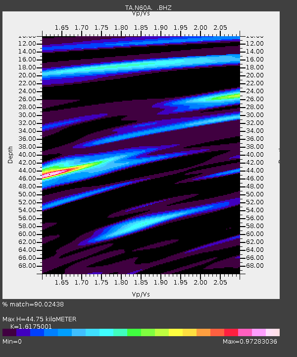
N60A Cedar Hill Farm, Mount Bethel, PA, USA - Earthquake Result Viewer

Earthquake location: Off East Coast Of Honshu, Japan
Earthquake latitude/longitude: 37.2/144.7
Earthquake time(UTC): 2013/10/25 (298) 17:10:19 GMT
Earthquake Depth: 35 km
Earthquake Magnitude: 7.1 MWW, 7.1 MWW, 7.1 MWB, 7.1 MWC, 7.2 MWC, 7.5 MI
Earthquake Catalog/Contributor: NEIC PDE/NEIC COMCAT
Network: TA USArray Transportable Network (new EarthScope stations)
Station: N60A Cedar Hill Farm, Mount Bethel, PA, USA
Lat/Lon: 40.87 N/75.10 W
Elevation: 189 m
Distance: 94.2 deg
Az: 29.102 deg
Baz: 329.177 deg
Ray Param: 0.041078445
Estimated Moho Depth: 44.75 km
Estimated Crust Vp/Vs: 1.62
Assumed Crust Vp: 6.283 km/s
Estimated Crust Vs: 3.885 km/s
Estimated Crust Poisson's Ratio: 0.19
Radial Match: 90.02438 %
Radial Bump: 400
Transverse Match: 60.997887 %
Transverse Bump: 400
SOD ConfigId: 626651
Insert Time: 2014-04-19 06:13:50.092 +0000
GWidth: 2.5
Max Bumps: 400
Tol: 0.001

Signal To Noise

ChannelStoNSTALTA
TA:N60A: :BHZ:20131025T17:23:03.800027Z7.2245442.1735536E-63.0085684E-7
TA:N60A: :BHN:20131025T17:23:03.800027Z3.14883236.64319E-72.1097313E-7
TA:N60A: :BHE:20131025T17:23:03.800027Z4.2272665.765579E-71.3639027E-7
Arrivals
Ps4.5 SECOND
PpPs18 SECOND
PsPs/PpSs23 SECOND