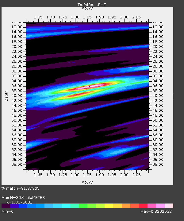
P48A Milroy, IN, USA - Earthquake Result Viewer

Earthquake location: Off East Coast Of Honshu, Japan
Earthquake latitude/longitude: 37.2/144.7
Earthquake time(UTC): 2013/10/25 (298) 17:10:19 GMT
Earthquake Depth: 35 km
Earthquake Magnitude: 7.1 MWW, 7.1 MWW, 7.1 MWB, 7.1 MWC, 7.2 MWC, 7.5 MI
Earthquake Catalog/Contributor: NEIC PDE/NEIC COMCAT
Network: TA USArray Transportable Network (new EarthScope stations)
Station: P48A Milroy, IN, USA
Lat/Lon: 39.46 N/85.43 W
Elevation: 300 m
Distance: 90.9 deg
Az: 36.432 deg
Baz: 322.202 deg
Ray Param: 0.041634247
Estimated Moho Depth: 36.0 km
Estimated Crust Vp/Vs: 1.86
Assumed Crust Vp: 6.498 km/s
Estimated Crust Vs: 3.498 km/s
Estimated Crust Poisson's Ratio: 0.30
Radial Match: 91.37305 %
Radial Bump: 373
Transverse Match: 79.961426 %
Transverse Bump: 400
SOD ConfigId: 626651
Insert Time: 2014-04-19 06:14:44.868 +0000
GWidth: 2.5
Max Bumps: 400
Tol: 0.001

Signal To Noise

ChannelStoNSTALTA
TA:P48A: :BHZ:20131025T17:22:48.624978Z25.9833743.7242417E-61.4333172E-7
TA:P48A: :BHN:20131025T17:22:48.624978Z3.05033021.2616767E-64.1361972E-7
TA:P48A: :BHE:20131025T17:22:48.624978Z2.23541267.8417105E-73.5079478E-7
Arrivals
Ps4.8 SECOND
PpPs16 SECOND
PsPs/PpSs20 SECOND