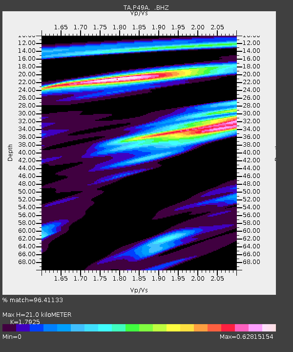
P49A Miami Univ. Ecology Research Center, OH, USA - Earthquake Result Viewer

Earthquake location: Off East Coast Of Honshu, Japan
Earthquake latitude/longitude: 37.2/144.7
Earthquake time(UTC): 2013/10/25 (298) 17:10:19 GMT
Earthquake Depth: 35 km
Earthquake Magnitude: 7.1 MWW, 7.1 MWW, 7.1 MWB, 7.1 MWC, 7.2 MWC, 7.5 MI
Earthquake Catalog/Contributor: NEIC PDE/NEIC COMCAT
Network: TA USArray Transportable Network (new EarthScope stations)
Station: P49A Miami Univ. Ecology Research Center, OH, USA
Lat/Lon: 39.53 N/84.72 W
Elevation: 272 m
Distance: 91.2 deg
Az: 35.952 deg
Baz: 322.66 deg
Ray Param: 0.04161454
Estimated Moho Depth: 21.0 km
Estimated Crust Vp/Vs: 1.79
Assumed Crust Vp: 6.498 km/s
Estimated Crust Vs: 3.625 km/s
Estimated Crust Poisson's Ratio: 0.27
Radial Match: 96.41133 %
Radial Bump: 395
Transverse Match: 84.90412 %
Transverse Bump: 400
SOD ConfigId: 626651
Insert Time: 2014-04-19 06:14:50.343 +0000
GWidth: 2.5
Max Bumps: 400
Tol: 0.001

Signal To Noise

ChannelStoNSTALTA
TA:P49A: :BHZ:20131025T17:22:49.900002Z7.31618553.5690173E-64.878249E-7
TA:P49A: :BHN:20131025T17:22:49.900002Z2.74318348.19144E-72.9861076E-7
TA:P49A: :BHE:20131025T17:22:49.900002Z4.4596318.681615E-71.9467116E-7
Arrivals
Ps2.6 SECOND
PpPs8.8 SECOND
PsPs/PpSs11 SECOND