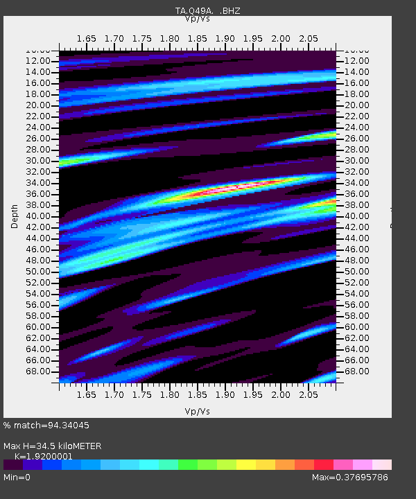
Q49A Aurora, IN, USA - Earthquake Result Viewer

Earthquake location: Off East Coast Of Honshu, Japan
Earthquake latitude/longitude: 37.2/144.7
Earthquake time(UTC): 2013/10/25 (298) 17:10:19 GMT
Earthquake Depth: 35 km
Earthquake Magnitude: 7.1 MWW, 7.1 MWW, 7.1 MWB, 7.1 MWC, 7.2 MWC, 7.5 MI
Earthquake Catalog/Contributor: NEIC PDE/NEIC COMCAT
Network: TA USArray Transportable Network (new EarthScope stations)
Station: Q49A Aurora, IN, USA
Lat/Lon: 39.01 N/84.90 W
Elevation: 264 m
Distance: 91.5 deg
Az: 36.383 deg
Baz: 322.537 deg
Ray Param: 0.04158547
Estimated Moho Depth: 34.5 km
Estimated Crust Vp/Vs: 1.92
Assumed Crust Vp: 6.498 km/s
Estimated Crust Vs: 3.384 km/s
Estimated Crust Poisson's Ratio: 0.31
Radial Match: 94.34045 %
Radial Bump: 324
Transverse Match: 87.94248 %
Transverse Bump: 400
SOD ConfigId: 626651
Insert Time: 2014-04-19 06:15:31.847 +0000
GWidth: 2.5
Max Bumps: 400
Tol: 0.001

Signal To Noise

ChannelStoNSTALTA
TA:Q49A: :BHZ:20131025T17:22:51.44999Z13.1733453.4101536E-62.5886771E-7
TA:Q49A: :BHN:20131025T17:22:51.44999Z8.8458921.3691968E-61.5478334E-7
TA:Q49A: :BHE:20131025T17:22:51.44999Z3.77155381.008142E-62.6730152E-7
Arrivals
Ps5.0 SECOND
PpPs15 SECOND
PsPs/PpSs20 SECOND