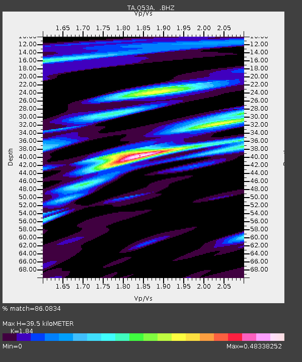
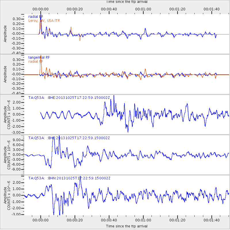
Q53A Leroy, WV, USA - Earthquake Result Viewer

Earthquake location: Off East Coast Of Honshu, Japan
Earthquake latitude/longitude: 37.2/144.7
Earthquake time(UTC): 2013/10/25 (298) 17:10:19 GMT
Earthquake Depth: 35 km
Earthquake Magnitude: 7.1 MWW, 7.1 MWW, 7.1 MWB, 7.1 MWC, 7.2 MWC, 7.5 MI
Earthquake Catalog/Contributor: NEIC PDE/NEIC COMCAT
Network: TA USArray Transportable Network (new EarthScope stations)
Station: Q53A Leroy, WV, USA
Lat/Lon: 38.86 N/81.53 W
Elevation: 310 m
Distance: 93.2 deg
Az: 34.352 deg
Baz: 324.731 deg
Ray Param: 0.041293107
Estimated Moho Depth: 39.5 km
Estimated Crust Vp/Vs: 1.84
Assumed Crust Vp: 6.207 km/s
Estimated Crust Vs: 3.373 km/s
Estimated Crust Poisson's Ratio: 0.29
Radial Match: 86.0834 %
Radial Bump: 390
Transverse Match: 69.90918 %
Transverse Bump: 400
SOD ConfigId: 626651
Insert Time: 2014-04-19 06:15:43.417 +0000
GWidth: 2.5
Max Bumps: 400
Tol: 0.001

Signal To Noise

ChannelStoNSTALTA
TA:Q53A: :BHZ:20131025T17:22:59.150002Z6.6467922.7790943E-64.1811063E-7
TA:Q53A: :BHN:20131025T17:22:59.150002Z2.16527276.970563E-73.2192543E-7
TA:Q53A: :BHE:20131025T17:22:59.150002Z1.40043155.0821427E-73.6289833E-7
Arrivals
Ps5.4 SECOND
PpPs18 SECOND
PsPs/PpSs23 SECOND