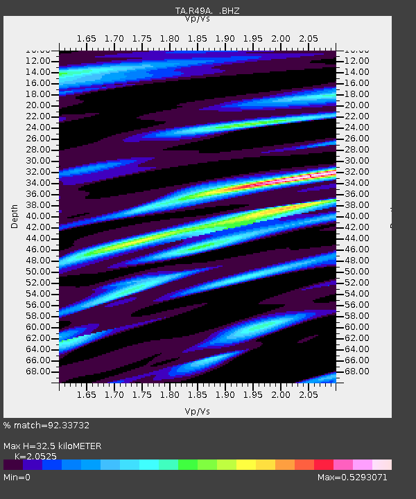
R49A Shelbyville, KY, USA - Earthquake Result Viewer
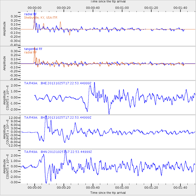
Earthquake location: Off East Coast Of Honshu, Japan
Earthquake latitude/longitude: 37.2/144.7
Earthquake time(UTC): 2013/10/25 (298) 17:10:19 GMT
Earthquake Depth: 35 km
Earthquake Magnitude: 7.1 MWW, 7.1 MWW, 7.1 MWB, 7.1 MWC, 7.2 MWC, 7.5 MI
Earthquake Catalog/Contributor: NEIC PDE/NEIC COMCAT
Network: TA USArray Transportable Network (new EarthScope stations)
Station: R49A Shelbyville, KY, USA
Lat/Lon: 38.29 N/85.17 W
Elevation: 251 m
Distance: 92.0 deg
Az: 36.989 deg
Baz: 322.347 deg
Ray Param: 0.041519843
Estimated Moho Depth: 32.5 km
Estimated Crust Vp/Vs: 2.05
Assumed Crust Vp: 6.498 km/s
Estimated Crust Vs: 3.166 km/s
Estimated Crust Poisson's Ratio: 0.34
Radial Match: 92.33732 %
Radial Bump: 400
Transverse Match: 82.1853 %
Transverse Bump: 400
SOD ConfigId: 626651
Insert Time: 2014-04-19 06:16:09.681 +0000
GWidth: 2.5
Max Bumps: 400
Tol: 0.001

Signal To Noise

ChannelStoNSTALTA
TA:R49A: :BHZ:20131025T17:22:53.44999Z15.5619313.2578812E-62.0934942E-7
TA:R49A: :BHN:20131025T17:22:53.44999Z3.22384646.7627764E-72.0977353E-7
TA:R49A: :BHE:20131025T17:22:53.44999Z1.74595154.840137E-72.7722058E-7
Arrivals
Ps5.4 SECOND
PpPs15 SECOND
PsPs/PpSs20 SECOND