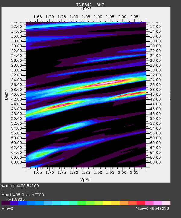
R54A Victor, WV, USA - Earthquake Result Viewer

Earthquake location: Off East Coast Of Honshu, Japan
Earthquake latitude/longitude: 37.2/144.7
Earthquake time(UTC): 2013/10/25 (298) 17:10:19 GMT
Earthquake Depth: 35 km
Earthquake Magnitude: 7.1 MWW, 7.1 MWW, 7.1 MWB, 7.1 MWC, 7.2 MWC, 7.5 MI
Earthquake Catalog/Contributor: NEIC PDE/NEIC COMCAT
Network: TA USArray Transportable Network (new EarthScope stations)
Station: R54A Victor, WV, USA
Lat/Lon: 38.18 N/80.99 W
Elevation: 512 m
Distance: 94.0 deg
Az: 34.398 deg
Baz: 325.059 deg
Ray Param: 0.041129854
Estimated Moho Depth: 35.0 km
Estimated Crust Vp/Vs: 1.93
Assumed Crust Vp: 6.207 km/s
Estimated Crust Vs: 3.212 km/s
Estimated Crust Poisson's Ratio: 0.32
Radial Match: 88.54189 %
Radial Bump: 400
Transverse Match: 71.92729 %
Transverse Bump: 400
SOD ConfigId: 626651
Insert Time: 2014-04-19 06:16:21.371 +0000
GWidth: 2.5
Max Bumps: 400
Tol: 0.001

Signal To Noise

ChannelStoNSTALTA
TA:R54A: :BHZ:20131025T17:23:02.800027Z5.45862532.299365E-64.2123517E-7
TA:R54A: :BHN:20131025T17:23:02.800027Z3.6571088.071844E-72.2071659E-7
TA:R54A: :BHE:20131025T17:23:02.800027Z1.57079524.53014E-72.8839787E-7
Arrivals
Ps5.3 SECOND
PpPs16 SECOND
PsPs/PpSs22 SECOND