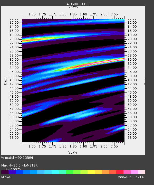
R58B Mineral, VA, USA - Earthquake Result Viewer
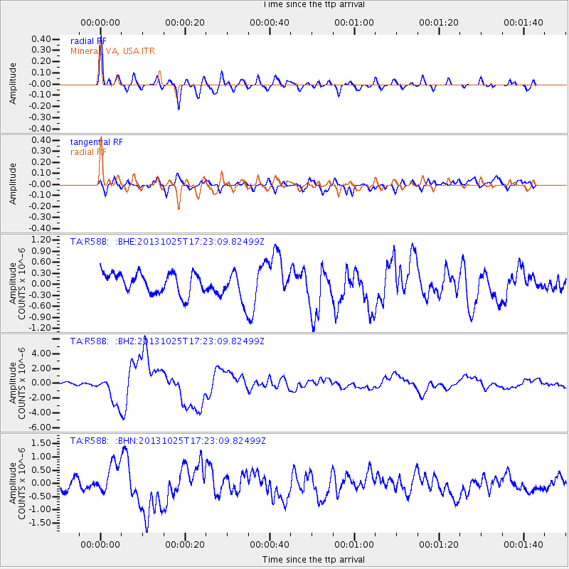
Earthquake location: Off East Coast Of Honshu, Japan
Earthquake latitude/longitude: 37.2/144.7
Earthquake time(UTC): 2013/10/25 (298) 17:10:19 GMT
Earthquake Depth: 35 km
Earthquake Magnitude: 7.1 MWW, 7.1 MWW, 7.1 MWB, 7.1 MWC, 7.2 MWC, 7.5 MI
Earthquake Catalog/Contributor: NEIC PDE/NEIC COMCAT
Network: TA USArray Transportable Network (new EarthScope stations)
Station: R58B Mineral, VA, USA
Lat/Lon: 37.96 N/77.88 W
Elevation: 116 m
Distance: 95.6 deg
Az: 32.474 deg
Baz: 327.131 deg
Ray Param: 0.040734492
Estimated Moho Depth: 30.0 km
Estimated Crust Vp/Vs: 2.06
Assumed Crust Vp: 6.565 km/s
Estimated Crust Vs: 3.183 km/s
Estimated Crust Poisson's Ratio: 0.35
Radial Match: 90.13596 %
Radial Bump: 400
Transverse Match: 66.81495 %
Transverse Bump: 400
SOD ConfigId: 626651
Insert Time: 2014-04-19 06:16:35.801 +0000
GWidth: 2.5
Max Bumps: 400
Tol: 0.001

Signal To Noise

ChannelStoNSTALTA
TA:R58B: :BHZ:20131025T17:23:09.82499Z9.384082.0290809E-62.1622587E-7
TA:R58B: :BHN:20131025T17:23:09.82499Z2.84975655.8248156E-72.0439695E-7
TA:R58B: :BHE:20131025T17:23:09.82499Z1.62120714.4367272E-72.7366812E-7
Arrivals
Ps4.9 SECOND
PpPs14 SECOND
PsPs/PpSs19 SECOND