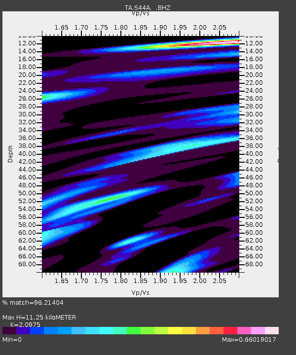
S44A Carbondale, IL, USA - Earthquake Result Viewer
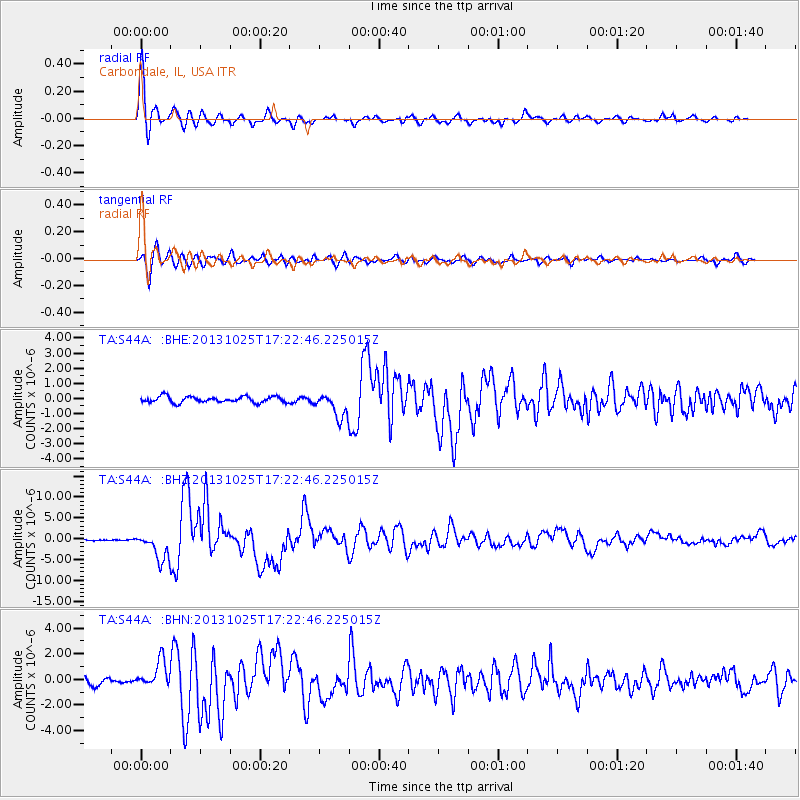
Earthquake location: Off East Coast Of Honshu, Japan
Earthquake latitude/longitude: 37.2/144.7
Earthquake time(UTC): 2013/10/25 (298) 17:10:19 GMT
Earthquake Depth: 35 km
Earthquake Magnitude: 7.1 MWW, 7.1 MWW, 7.1 MWB, 7.1 MWC, 7.2 MWC, 7.5 MI
Earthquake Catalog/Contributor: NEIC PDE/NEIC COMCAT
Network: TA USArray Transportable Network (new EarthScope stations)
Station: S44A Carbondale, IL, USA
Lat/Lon: 37.69 N/89.26 W
Elevation: 155 m
Distance: 90.4 deg
Az: 39.874 deg
Baz: 319.783 deg
Ray Param: 0.041671257
Estimated Moho Depth: 11.25 km
Estimated Crust Vp/Vs: 2.10
Assumed Crust Vp: 6.444 km/s
Estimated Crust Vs: 3.072 km/s
Estimated Crust Poisson's Ratio: 0.35
Radial Match: 96.21404 %
Radial Bump: 400
Transverse Match: 89.13373 %
Transverse Bump: 400
SOD ConfigId: 626651
Insert Time: 2014-04-19 06:16:45.157 +0000
GWidth: 2.5
Max Bumps: 400
Tol: 0.001

Signal To Noise

ChannelStoNSTALTA
TA:S44A: :BHZ:20131025T17:22:46.225015Z15.30631353.2996484E-62.1557433E-7
TA:S44A: :BHN:20131025T17:22:46.225015Z3.03057771.071442E-63.5354384E-7
TA:S44A: :BHE:20131025T17:22:46.225015Z4.17460258.2034626E-71.9650882E-7
Arrivals
Ps2.0 SECOND
PpPs5.3 SECOND
PsPs/PpSs7.3 SECOND