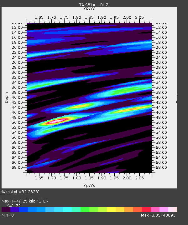
S51A Beattyville, KY, USA - Earthquake Result Viewer

Earthquake location: Off East Coast Of Honshu, Japan
Earthquake latitude/longitude: 37.2/144.7
Earthquake time(UTC): 2013/10/25 (298) 17:10:19 GMT
Earthquake Depth: 35 km
Earthquake Magnitude: 7.1 MWW, 7.1 MWW, 7.1 MWB, 7.1 MWC, 7.2 MWC, 7.5 MI
Earthquake Catalog/Contributor: NEIC PDE/NEIC COMCAT
Network: TA USArray Transportable Network (new EarthScope stations)
Station: S51A Beattyville, KY, USA
Lat/Lon: 37.64 N/83.59 W
Elevation: 286 m
Distance: 93.2 deg
Az: 36.388 deg
Baz: 323.341 deg
Ray Param: 0.0412874
Estimated Moho Depth: 49.25 km
Estimated Crust Vp/Vs: 1.72
Assumed Crust Vp: 6.476 km/s
Estimated Crust Vs: 3.765 km/s
Estimated Crust Poisson's Ratio: 0.24
Radial Match: 92.26381 %
Radial Bump: 400
Transverse Match: 75.87225 %
Transverse Bump: 400
SOD ConfigId: 626651
Insert Time: 2014-04-19 06:16:53.736 +0000
GWidth: 2.5
Max Bumps: 400
Tol: 0.001

Signal To Noise

ChannelStoNSTALTA
TA:S51A: :BHZ:20131025T17:22:59.300027Z6.9153642.2224413E-63.2137734E-7
TA:S51A: :BHN:20131025T17:22:59.300027Z3.85812386.621733E-71.7163092E-7
TA:S51A: :BHE:20131025T17:22:59.300027Z1.57066024.775881E-73.0406838E-7
Arrivals
Ps5.6 SECOND
PpPs20 SECOND
PsPs/PpSs26 SECOND