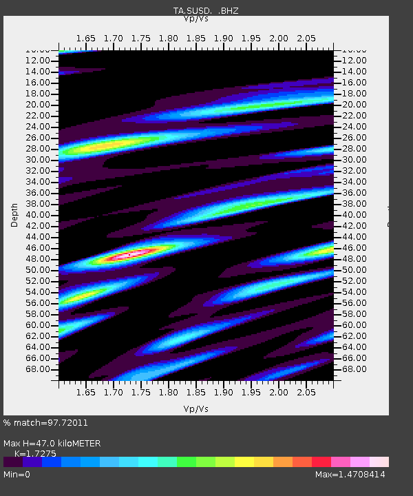
SUSD Miller, SD, USA - Earthquake Result Viewer

Earthquake location: Off East Coast Of Honshu, Japan
Earthquake latitude/longitude: 37.2/144.7
Earthquake time(UTC): 2013/10/25 (298) 17:10:19 GMT
Earthquake Depth: 35 km
Earthquake Magnitude: 7.1 MWW, 7.1 MWW, 7.1 MWB, 7.1 MWC, 7.2 MWC, 7.5 MI
Earthquake Catalog/Contributor: NEIC PDE/NEIC COMCAT
Network: TA USArray Transportable Network (new EarthScope stations)
Station: SUSD Miller, SD, USA
Lat/Lon: 44.44 N/98.96 W
Elevation: 520 m
Distance: 80.5 deg
Az: 40.59 deg
Baz: 313.471 deg
Ray Param: 0.048197396
Estimated Moho Depth: 47.0 km
Estimated Crust Vp/Vs: 1.73
Assumed Crust Vp: 6.53 km/s
Estimated Crust Vs: 3.78 km/s
Estimated Crust Poisson's Ratio: 0.25
Radial Match: 97.72011 %
Radial Bump: 400
Transverse Match: 94.071335 %
Transverse Bump: 400
SOD ConfigId: 626651
Insert Time: 2014-04-19 06:17:26.022 +0000
GWidth: 2.5
Max Bumps: 400
Tol: 0.001

Signal To Noise

ChannelStoNSTALTA
TA:SUSD: :BHZ:20131025T17:21:56.973977Z26.9941626.0655866E-62.2469993E-7
TA:SUSD: :BHN:20131025T17:21:56.973977Z6.21687562.2224185E-63.5748155E-7
TA:SUSD: :BHE:20131025T17:21:56.973977Z11.1171712.5264835E-62.2725958E-7
Arrivals
Ps5.4 SECOND
PpPs19 SECOND
PsPs/PpSs24 SECOND