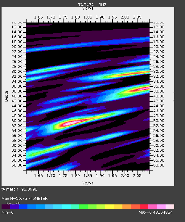
T47A Sharon Grove, KY, USA - Earthquake Result Viewer
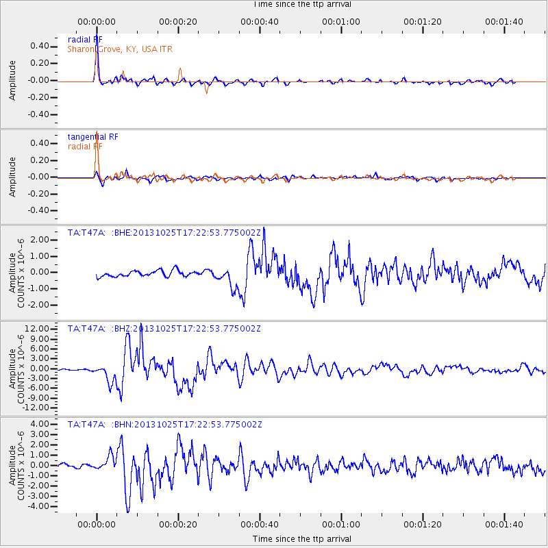
Earthquake location: Off East Coast Of Honshu, Japan
Earthquake latitude/longitude: 37.2/144.7
Earthquake time(UTC): 2013/10/25 (298) 17:10:19 GMT
Earthquake Depth: 35 km
Earthquake Magnitude: 7.1 MWW, 7.1 MWW, 7.1 MWB, 7.1 MWC, 7.2 MWC, 7.5 MI
Earthquake Catalog/Contributor: NEIC PDE/NEIC COMCAT
Network: TA USArray Transportable Network (new EarthScope stations)
Station: T47A Sharon Grove, KY, USA
Lat/Lon: 36.99 N/87.11 W
Elevation: 217 m
Distance: 92.0 deg
Az: 39.002 deg
Baz: 321.1 deg
Ray Param: 0.04150919
Estimated Moho Depth: 50.75 km
Estimated Crust Vp/Vs: 1.78
Assumed Crust Vp: 6.444 km/s
Estimated Crust Vs: 3.62 km/s
Estimated Crust Poisson's Ratio: 0.27
Radial Match: 96.0998 %
Radial Bump: 329
Transverse Match: 84.78767 %
Transverse Bump: 400
SOD ConfigId: 626651
Insert Time: 2014-04-19 06:17:31.054 +0000
GWidth: 2.5
Max Bumps: 400
Tol: 0.001

Signal To Noise

ChannelStoNSTALTA
TA:T47A: :BHZ:20131025T17:22:53.775002Z25.2808952.7871095E-61.1024568E-7
TA:T47A: :BHN:20131025T17:22:53.775002Z3.82855136.955975E-71.8168687E-7
TA:T47A: :BHE:20131025T17:22:53.775002Z3.5654026.4231494E-71.8015217E-7
Arrivals
Ps6.3 SECOND
PpPs21 SECOND
PsPs/PpSs28 SECOND