T50A Nancy, KY, USA - Earthquake Result Viewer
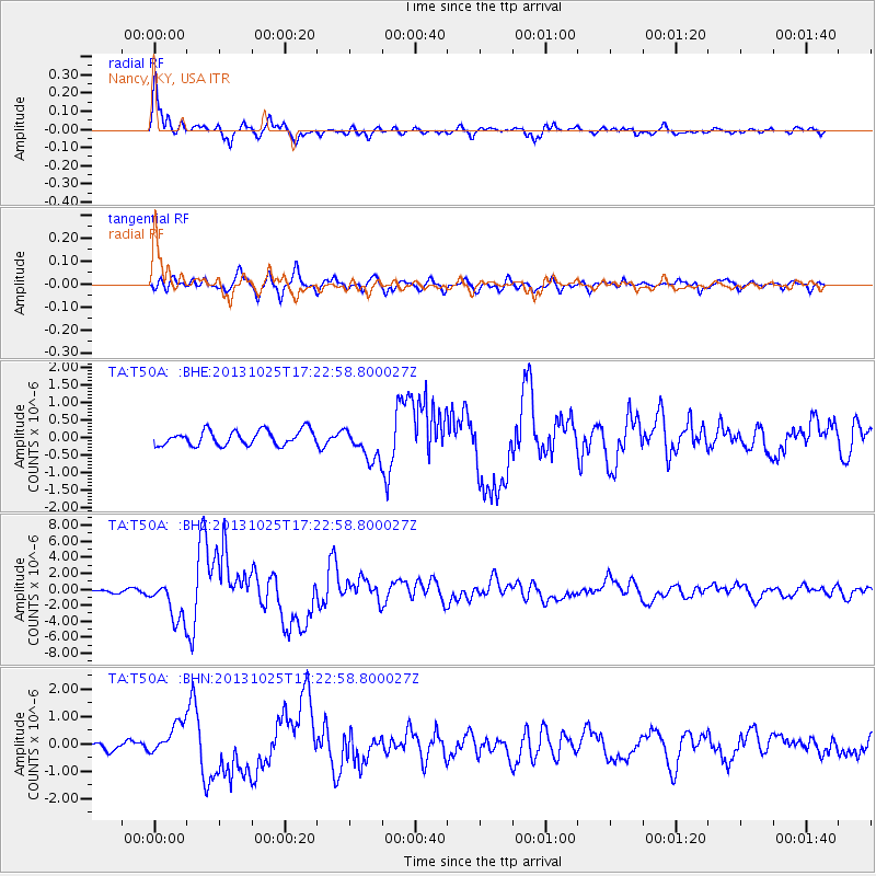
Earthquake location: Off East Coast Of Honshu, Japan
Earthquake latitude/longitude: 37.2/144.7
Earthquake time(UTC): 2013/10/25 (298) 17:10:19 GMT
Earthquake Depth: 35 km
Earthquake Magnitude: 7.1 MWW, 7.1 MWW, 7.1 MWB, 7.1 MWC, 7.2 MWC, 7.5 MI
Earthquake Catalog/Contributor: NEIC PDE/NEIC COMCAT
Network: TA USArray Transportable Network (new EarthScope stations)
Station: T50A Nancy, KY, USA
Lat/Lon: 37.02 N/84.84 W
Elevation: 302 m
Distance: 93.1 deg
Az: 37.554 deg
Baz: 322.524 deg
Ray Param: 0.041308217
Estimated Moho Depth: 45.0 km
Estimated Crust Vp/Vs: 1.60
Assumed Crust Vp: 6.476 km/s
Estimated Crust Vs: 4.047 km/s
Estimated Crust Poisson's Ratio: 0.18
Radial Match: 92.08544 %
Radial Bump: 400
Transverse Match: 86.50235 %
Transverse Bump: 400
SOD ConfigId: 626651
Insert Time: 2014-04-19 06:17:35.973 +0000
GWidth: 2.5
Max Bumps: 400
Tol: 0.001

Signal To Noise

ChannelStoNSTALTA
TA:T50A: :BHZ:20131025T17:22:58.800027Z12.7263492.5408474E-61.996525E-7
TA:T50A: :BHN:20131025T17:22:58.800027Z3.9197555.6351735E-71.437634E-7
TA:T50A: :BHE:20131025T17:22:58.800027Z2.2092464.6604413E-72.1095168E-7
Arrivals
Ps4.3 SECOND
PpPs18 SECOND
PsPs/PpSs22 SECOND