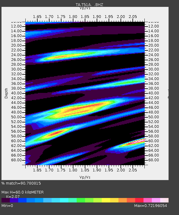
T51A Gray, KY, USA - Earthquake Result Viewer

Earthquake location: Off East Coast Of Honshu, Japan
Earthquake latitude/longitude: 37.2/144.7
Earthquake time(UTC): 2013/10/25 (298) 17:10:19 GMT
Earthquake Depth: 35 km
Earthquake Magnitude: 7.1 MWW, 7.1 MWW, 7.1 MWB, 7.1 MWC, 7.2 MWC, 7.5 MI
Earthquake Catalog/Contributor: NEIC PDE/NEIC COMCAT
Network: TA USArray Transportable Network (new EarthScope stations)
Station: T51A Gray, KY, USA
Lat/Lon: 36.97 N/83.95 W
Elevation: 329 m
Distance: 93.6 deg
Az: 37.017 deg
Baz: 323.091 deg
Ray Param: 0.041214142
Estimated Moho Depth: 60.0 km
Estimated Crust Vp/Vs: 2.07
Assumed Crust Vp: 6.476 km/s
Estimated Crust Vs: 3.128 km/s
Estimated Crust Poisson's Ratio: 0.35
Radial Match: 90.780815 %
Radial Bump: 400
Transverse Match: 74.59286 %
Transverse Bump: 400
SOD ConfigId: 626651
Insert Time: 2014-04-19 06:17:36.307 +0000
GWidth: 2.5
Max Bumps: 400
Tol: 0.001

Signal To Noise

ChannelStoNSTALTA
TA:T51A: :BHZ:20131025T17:23:00.973977Z12.3276232.424011E-61.9663247E-7
TA:T51A: :BHN:20131025T17:23:00.973977Z2.2907245.9257843E-72.5868607E-7
TA:T51A: :BHE:20131025T17:23:00.973977Z2.8122314.5335733E-71.6120913E-7
Arrivals
Ps10 SECOND
PpPs28 SECOND
PsPs/PpSs38 SECOND