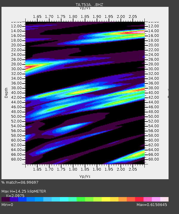
T53A Wise, VA, USA - Earthquake Result Viewer
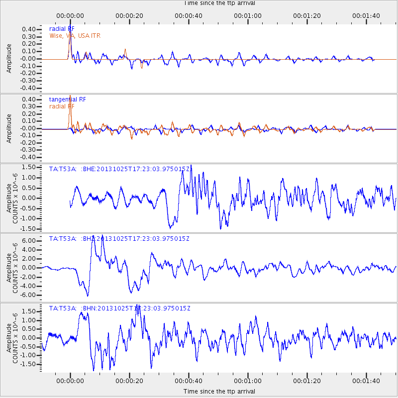
Earthquake location: Off East Coast Of Honshu, Japan
Earthquake latitude/longitude: 37.2/144.7
Earthquake time(UTC): 2013/10/25 (298) 17:10:19 GMT
Earthquake Depth: 35 km
Earthquake Magnitude: 7.1 MWW, 7.1 MWW, 7.1 MWB, 7.1 MWC, 7.2 MWC, 7.5 MI
Earthquake Catalog/Contributor: NEIC PDE/NEIC COMCAT
Network: TA USArray Transportable Network (new EarthScope stations)
Station: T53A Wise, VA, USA
Lat/Lon: 36.98 N/82.54 W
Elevation: 818 m
Distance: 94.3 deg
Az: 36.096 deg
Baz: 323.999 deg
Ray Param: 0.04106855
Estimated Moho Depth: 14.25 km
Estimated Crust Vp/Vs: 2.10
Assumed Crust Vp: 6.476 km/s
Estimated Crust Vs: 3.087 km/s
Estimated Crust Poisson's Ratio: 0.35
Radial Match: 86.99697 %
Radial Bump: 400
Transverse Match: 65.21907 %
Transverse Bump: 400
SOD ConfigId: 626651
Insert Time: 2014-04-19 06:17:41.204 +0000
GWidth: 2.5
Max Bumps: 400
Tol: 0.001

Signal To Noise

ChannelStoNSTALTA
TA:T53A: :BHZ:20131025T17:23:03.975015Z7.10578732.1285807E-62.9955592E-7
TA:T53A: :BHN:20131025T17:23:03.975015Z3.11850527.961513E-72.5529903E-7
TA:T53A: :BHE:20131025T17:23:03.975015Z3.2209867.793817E-72.4196993E-7
Arrivals
Ps2.5 SECOND
PpPs6.7 SECOND
PsPs/PpSs9.2 SECOND