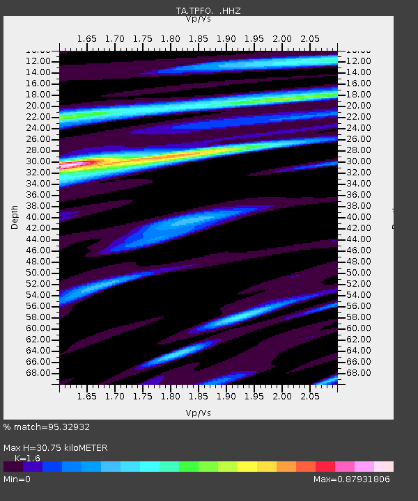
TPFO Pinon Flats, CA, USA - Earthquake Result Viewer
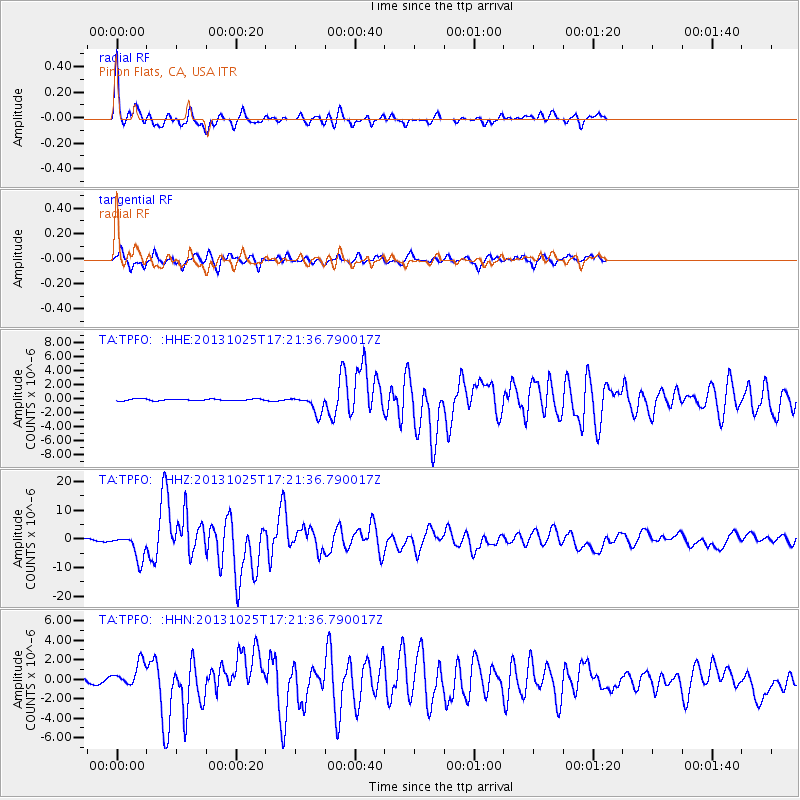
Earthquake location: Off East Coast Of Honshu, Japan
Earthquake latitude/longitude: 37.2/144.7
Earthquake time(UTC): 2013/10/25 (298) 17:10:19 GMT
Earthquake Depth: 35 km
Earthquake Magnitude: 7.1 MWW, 7.1 MWW, 7.1 MWB, 7.1 MWC, 7.2 MWC, 7.5 MI
Earthquake Catalog/Contributor: NEIC PDE/NEIC COMCAT
Network: TA USArray Transportable Network (new EarthScope stations)
Station: TPFO Pinon Flats, CA, USA
Lat/Lon: 33.61 N/116.45 W
Elevation: 1275 m
Distance: 76.8 deg
Az: 57.879 deg
Baz: 305.828 deg
Ray Param: 0.05069988
Estimated Moho Depth: 30.75 km
Estimated Crust Vp/Vs: 1.60
Assumed Crust Vp: 6.264 km/s
Estimated Crust Vs: 3.915 km/s
Estimated Crust Poisson's Ratio: 0.18
Radial Match: 95.32932 %
Radial Bump: 359
Transverse Match: 87.23895 %
Transverse Bump: 400
SOD ConfigId: 626651
Insert Time: 2014-04-19 06:18:11.036 +0000
GWidth: 2.5
Max Bumps: 400
Tol: 0.001

Signal To Noise

ChannelStoNSTALTA
TA:TPFO: :HHZ:20131025T17:21:36.790017Z10.7150164.4745407E-64.1759532E-7
TA:TPFO: :HHN:20131025T17:21:36.790017Z3.4968211.2131434E-63.4692752E-7
TA:TPFO: :HHE:20131025T17:21:36.790017Z9.7922621.2781509E-61.3052662E-7
Arrivals
Ps3.0 SECOND
PpPs12 SECOND
PsPs/PpSs15 SECOND