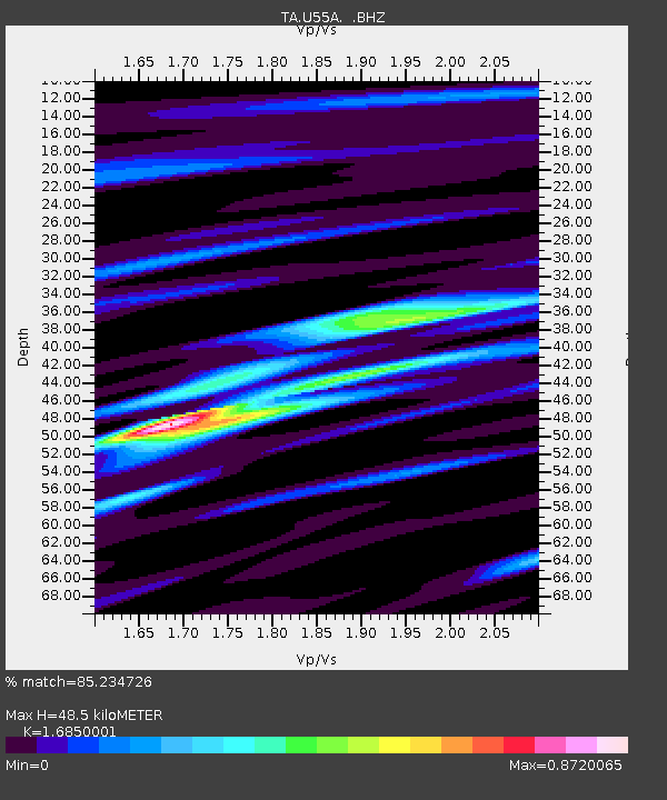
U55A TA2, Sparta, NC, USA - Earthquake Result Viewer
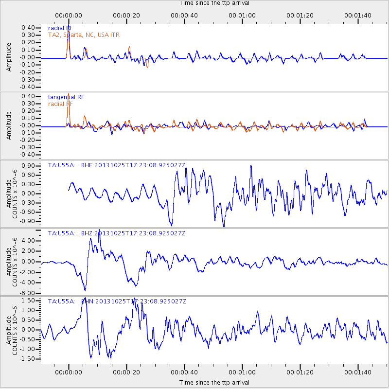
Earthquake location: Off East Coast Of Honshu, Japan
Earthquake latitude/longitude: 37.2/144.7
Earthquake time(UTC): 2013/10/25 (298) 17:10:19 GMT
Earthquake Depth: 35 km
Earthquake Magnitude: 7.1 MWW, 7.1 MWW, 7.1 MWB, 7.1 MWC, 7.2 MWC, 7.5 MI
Earthquake Catalog/Contributor: NEIC PDE/NEIC COMCAT
Network: TA USArray Transportable Network (new EarthScope stations)
Station: U55A TA2, Sparta, NC, USA
Lat/Lon: 36.50 N/81.05 W
Elevation: 863 m
Distance: 95.4 deg
Az: 35.399 deg
Baz: 324.943 deg
Ray Param: 0.040788475
Estimated Moho Depth: 48.5 km
Estimated Crust Vp/Vs: 1.69
Assumed Crust Vp: 6.159 km/s
Estimated Crust Vs: 3.655 km/s
Estimated Crust Poisson's Ratio: 0.23
Radial Match: 85.234726 %
Radial Bump: 400
Transverse Match: 71.56557 %
Transverse Bump: 400
SOD ConfigId: 626651
Insert Time: 2014-04-19 06:18:34.722 +0000
GWidth: 2.5
Max Bumps: 400
Tol: 0.001

Signal To Noise

ChannelStoNSTALTA
TA:U55A: :BHZ:20131025T17:23:08.925027Z9.9527321.7043907E-61.7124853E-7
TA:U55A: :BHN:20131025T17:23:08.925027Z2.40247185.5648576E-72.3163051E-7
TA:U55A: :BHE:20131025T17:23:08.925027Z2.33706283.539324E-71.5144326E-7
Arrivals
Ps5.5 SECOND
PpPs21 SECOND
PsPs/PpSs26 SECOND