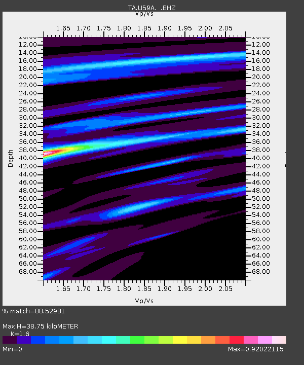
U59A Littleton, NC, USA - Earthquake Result Viewer

Earthquake location: Off East Coast Of Honshu, Japan
Earthquake latitude/longitude: 37.2/144.7
Earthquake time(UTC): 2013/10/25 (298) 17:10:19 GMT
Earthquake Depth: 35 km
Earthquake Magnitude: 7.1 MWW, 7.1 MWW, 7.1 MWB, 7.1 MWC, 7.2 MWC, 7.5 MI
Earthquake Catalog/Contributor: NEIC PDE/NEIC COMCAT
Network: TA USArray Transportable Network (new EarthScope stations)
Station: U59A Littleton, NC, USA
Lat/Lon: 36.35 N/77.79 W
Elevation: 99 m
Distance: 96.9 deg
Az: 33.294 deg
Baz: 327.094 deg
Ray Param: 0.040344737
Estimated Moho Depth: 38.75 km
Estimated Crust Vp/Vs: 1.60
Assumed Crust Vp: 6.565 km/s
Estimated Crust Vs: 4.103 km/s
Estimated Crust Poisson's Ratio: 0.18
Radial Match: 88.52981 %
Radial Bump: 400
Transverse Match: 70.8142 %
Transverse Bump: 400
SOD ConfigId: 626651
Insert Time: 2014-04-19 06:18:44.000 +0000
GWidth: 2.5
Max Bumps: 400
Tol: 0.001

Signal To Noise

ChannelStoNSTALTA
TA:U59A: :BHZ:20131025T17:23:16.07499Z7.24786761.5895573E-62.1931379E-7
TA:U59A: :BHN:20131025T17:23:16.07499Z2.26357535.471472E-72.417181E-7
TA:U59A: :BHE:20131025T17:23:16.07499Z1.80457154.1715887E-72.3116783E-7
Arrivals
Ps3.6 SECOND
PpPs15 SECOND
PsPs/PpSs19 SECOND