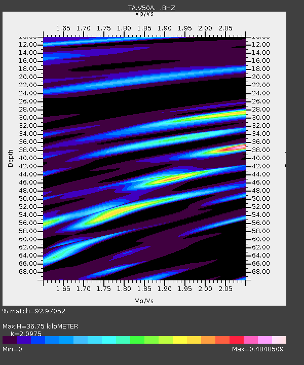
V50A Pikevile, TN, USA - Earthquake Result Viewer
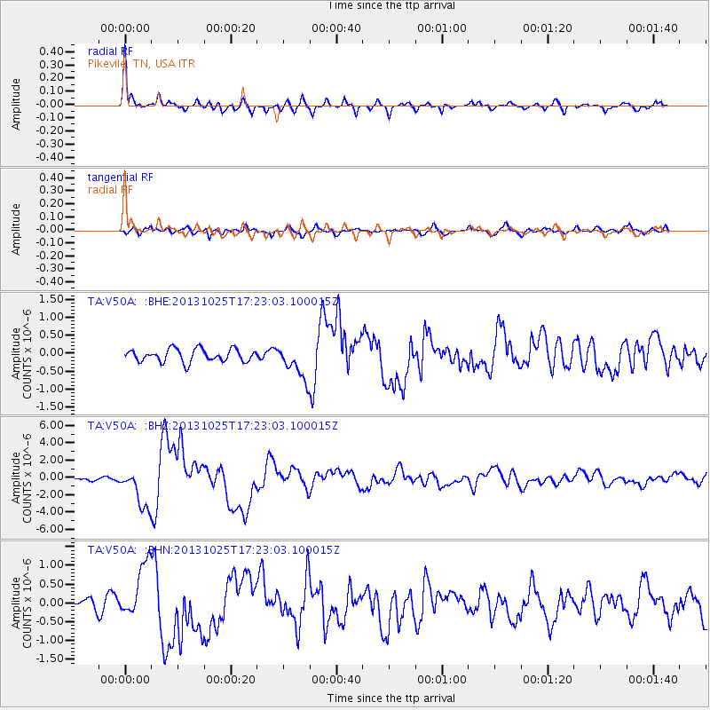
Earthquake location: Off East Coast Of Honshu, Japan
Earthquake latitude/longitude: 37.2/144.7
Earthquake time(UTC): 2013/10/25 (298) 17:10:19 GMT
Earthquake Depth: 35 km
Earthquake Magnitude: 7.1 MWW, 7.1 MWW, 7.1 MWB, 7.1 MWC, 7.2 MWC, 7.5 MI
Earthquake Catalog/Contributor: NEIC PDE/NEIC COMCAT
Network: TA USArray Transportable Network (new EarthScope stations)
Station: V50A Pikevile, TN, USA
Lat/Lon: 35.67 N/85.10 W
Elevation: 287 m
Distance: 94.1 deg
Az: 38.544 deg
Baz: 322.307 deg
Ray Param: 0.04111428
Estimated Moho Depth: 36.75 km
Estimated Crust Vp/Vs: 2.10
Assumed Crust Vp: 6.35 km/s
Estimated Crust Vs: 3.027 km/s
Estimated Crust Poisson's Ratio: 0.35
Radial Match: 92.97052 %
Radial Bump: 368
Transverse Match: 76.8196 %
Transverse Bump: 400
SOD ConfigId: 626651
Insert Time: 2014-04-19 06:18:54.249 +0000
GWidth: 2.5
Max Bumps: 400
Tol: 0.001

Signal To Noise

ChannelStoNSTALTA
TA:V50A: :BHZ:20131025T17:23:03.100015Z9.6875762.313211E-62.3878118E-7
TA:V50A: :BHN:20131025T17:23:03.100015Z5.81708967.336819E-71.2612524E-7
TA:V50A: :BHE:20131025T17:23:03.100015Z2.74151954.8311273E-71.7622078E-7
Arrivals
Ps6.5 SECOND
PpPs18 SECOND
PsPs/PpSs24 SECOND