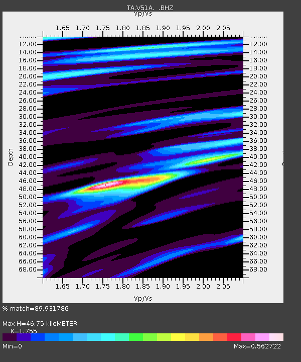
V51A Loudon, TN, USA - Earthquake Result Viewer

Earthquake location: Off East Coast Of Honshu, Japan
Earthquake latitude/longitude: 37.2/144.7
Earthquake time(UTC): 2013/10/25 (298) 17:10:19 GMT
Earthquake Depth: 35 km
Earthquake Magnitude: 7.1 MWW, 7.1 MWW, 7.1 MWB, 7.1 MWC, 7.2 MWC, 7.5 MI
Earthquake Catalog/Contributor: NEIC PDE/NEIC COMCAT
Network: TA USArray Transportable Network (new EarthScope stations)
Station: V51A Loudon, TN, USA
Lat/Lon: 35.80 N/84.35 W
Elevation: 243 m
Distance: 94.3 deg
Az: 37.979 deg
Baz: 322.784 deg
Ray Param: 0.041052032
Estimated Moho Depth: 46.75 km
Estimated Crust Vp/Vs: 1.75
Assumed Crust Vp: 6.35 km/s
Estimated Crust Vs: 3.618 km/s
Estimated Crust Poisson's Ratio: 0.26
Radial Match: 89.931786 %
Radial Bump: 400
Transverse Match: 75.255196 %
Transverse Bump: 400
SOD ConfigId: 626651
Insert Time: 2014-04-19 06:18:58.607 +0000
GWidth: 2.5
Max Bumps: 400
Tol: 0.001

Signal To Noise

ChannelStoNSTALTA
TA:V51A: :BHZ:20131025T17:23:04.300027Z7.77235032.254127E-62.9001868E-7
TA:V51A: :BHN:20131025T17:23:04.300027Z2.7474055.8590405E-72.1325724E-7
TA:V51A: :BHE:20131025T17:23:04.300027Z2.56233623.7349096E-71.4576189E-7
Arrivals
Ps5.7 SECOND
PpPs20 SECOND
PsPs/PpSs26 SECOND