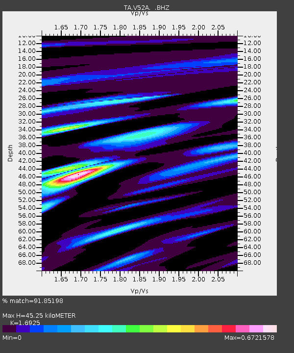
V52A Sevierville, TN, USA - Earthquake Result Viewer

Earthquake location: Off East Coast Of Honshu, Japan
Earthquake latitude/longitude: 37.2/144.7
Earthquake time(UTC): 2013/10/25 (298) 17:10:19 GMT
Earthquake Depth: 35 km
Earthquake Magnitude: 7.1 MWW, 7.1 MWW, 7.1 MWB, 7.1 MWC, 7.2 MWC, 7.5 MI
Earthquake Catalog/Contributor: NEIC PDE/NEIC COMCAT
Network: TA USArray Transportable Network (new EarthScope stations)
Station: V52A Sevierville, TN, USA
Lat/Lon: 35.84 N/83.60 W
Elevation: 328 m
Distance: 94.7 deg
Az: 37.464 deg
Baz: 323.265 deg
Ray Param: 0.040967718
Estimated Moho Depth: 45.25 km
Estimated Crust Vp/Vs: 1.69
Assumed Crust Vp: 6.35 km/s
Estimated Crust Vs: 3.752 km/s
Estimated Crust Poisson's Ratio: 0.23
Radial Match: 91.85198 %
Radial Bump: 400
Transverse Match: 69.52181 %
Transverse Bump: 400
SOD ConfigId: 626651
Insert Time: 2014-04-19 06:18:58.924 +0000
GWidth: 2.5
Max Bumps: 400
Tol: 0.001

Signal To Noise

ChannelStoNSTALTA
TA:V52A: :BHZ:20131025T17:23:05.850015Z8.7091352.216335E-62.5448395E-7
TA:V52A: :BHN:20131025T17:23:05.850015Z2.05158935.76759E-72.811279E-7
TA:V52A: :BHE:20131025T17:23:05.850015Z3.13134885.0413223E-71.6099524E-7
Arrivals
Ps5.0 SECOND
PpPs19 SECOND
PsPs/PpSs24 SECOND