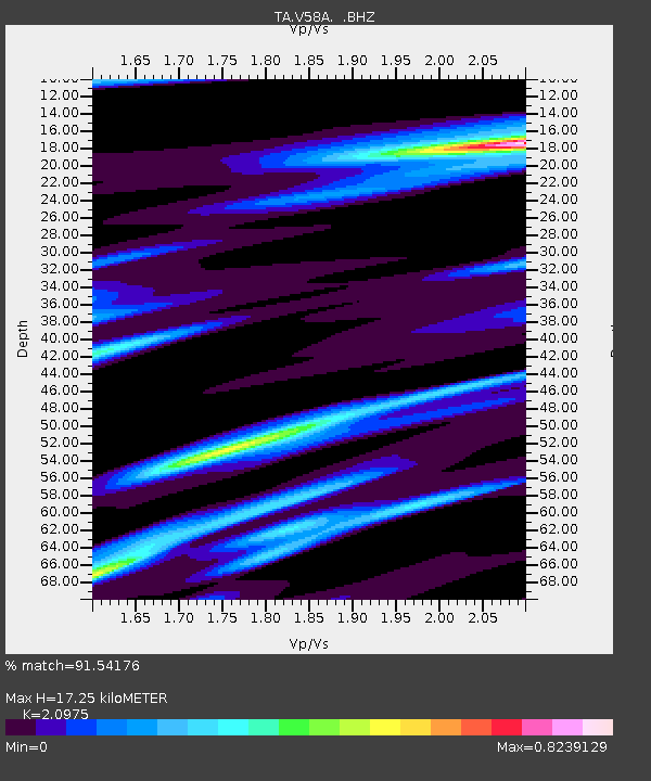
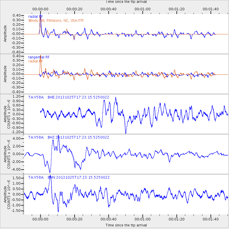
V58A Windy Hill, Pittsboro, NC, USA - Earthquake Result Viewer

Earthquake location: Off East Coast Of Honshu, Japan
Earthquake latitude/longitude: 37.2/144.7
Earthquake time(UTC): 2013/10/25 (298) 17:10:19 GMT
Earthquake Depth: 35 km
Earthquake Magnitude: 7.1 MWW, 7.1 MWW, 7.1 MWB, 7.1 MWC, 7.2 MWC, 7.5 MI
Earthquake Catalog/Contributor: NEIC PDE/NEIC COMCAT
Network: TA USArray Transportable Network (new EarthScope stations)
Station: V58A Windy Hill, Pittsboro, NC, USA
Lat/Lon: 35.79 N/79.11 W
Elevation: 127 m
Distance: 96.8 deg
Az: 34.504 deg
Baz: 326.173 deg
Ray Param: 0.04038204
Estimated Moho Depth: 17.25 km
Estimated Crust Vp/Vs: 2.10
Assumed Crust Vp: 6.565 km/s
Estimated Crust Vs: 3.13 km/s
Estimated Crust Poisson's Ratio: 0.35
Radial Match: 91.54176 %
Radial Bump: 400
Transverse Match: 61.989525 %
Transverse Bump: 400
SOD ConfigId: 626651
Insert Time: 2014-04-19 06:19:14.131 +0000
GWidth: 2.5
Max Bumps: 400
Tol: 0.001

Signal To Noise

ChannelStoNSTALTA
TA:V58A: :BHZ:20131025T17:23:15.525002Z8.5128341.7244288E-62.0256813E-7
TA:V58A: :BHN:20131025T17:23:15.525002Z2.2227253.394964E-71.5273883E-7
TA:V58A: :BHE:20131025T17:23:15.525002Z2.19422343.6955913E-71.6842367E-7
Arrivals
Ps2.9 SECOND
PpPs8.0 SECOND
PsPs/PpSs11 SECOND