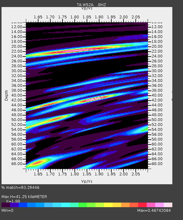
W52A Murphy, NC, USA - Earthquake Result Viewer
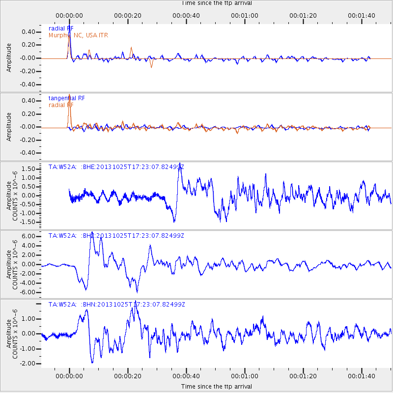
Earthquake location: Off East Coast Of Honshu, Japan
Earthquake latitude/longitude: 37.2/144.7
Earthquake time(UTC): 2013/10/25 (298) 17:10:19 GMT
Earthquake Depth: 35 km
Earthquake Magnitude: 7.1 MWW, 7.1 MWW, 7.1 MWB, 7.1 MWC, 7.2 MWC, 7.5 MI
Earthquake Catalog/Contributor: NEIC PDE/NEIC COMCAT
Network: TA USArray Transportable Network (new EarthScope stations)
Station: W52A Murphy, NC, USA
Lat/Lon: 35.09 N/83.93 W
Elevation: 519 m
Distance: 95.1 deg
Az: 38.131 deg
Baz: 323.016 deg
Ray Param: 0.040852282
Estimated Moho Depth: 41.25 km
Estimated Crust Vp/Vs: 1.88
Assumed Crust Vp: 6.35 km/s
Estimated Crust Vs: 3.378 km/s
Estimated Crust Poisson's Ratio: 0.30
Radial Match: 93.29446 %
Radial Bump: 400
Transverse Match: 72.85408 %
Transverse Bump: 400
SOD ConfigId: 626651
Insert Time: 2014-04-19 06:19:38.192 +0000
GWidth: 2.5
Max Bumps: 400
Tol: 0.001

Signal To Noise

ChannelStoNSTALTA
TA:W52A: :BHZ:20131025T17:23:07.82499Z13.637662.0211503E-61.482036E-7
TA:W52A: :BHN:20131025T17:23:07.82499Z4.51975066.246445E-71.382033E-7
TA:W52A: :BHE:20131025T17:23:07.82499Z1.95284143.55399E-71.8199073E-7
Arrivals
Ps5.8 SECOND
PpPs18 SECOND
PsPs/PpSs24 SECOND