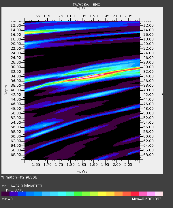
W58A Raeford, NC, USA - Earthquake Result Viewer
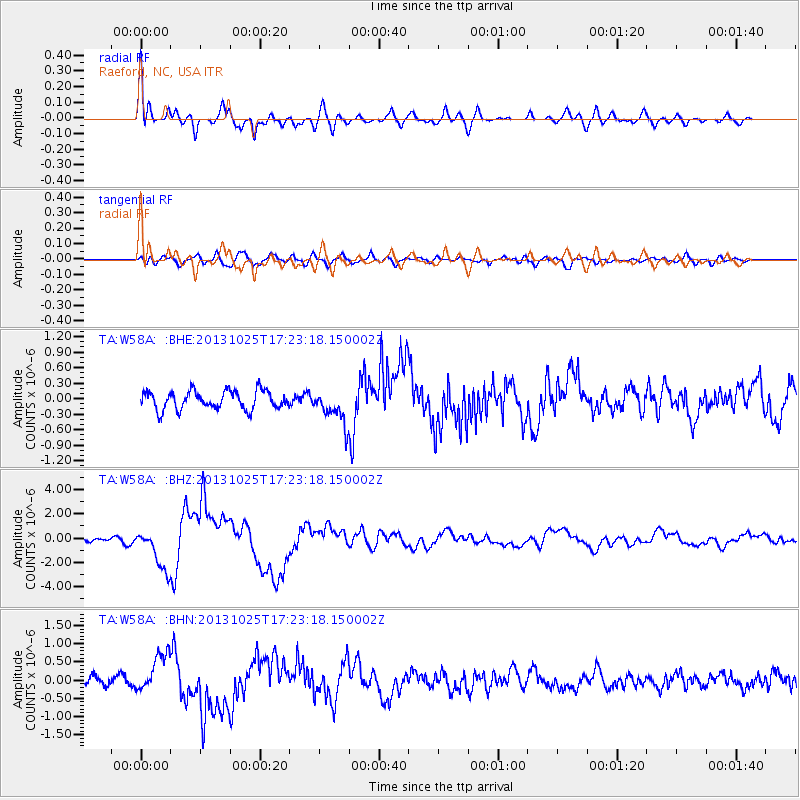
Earthquake location: Off East Coast Of Honshu, Japan
Earthquake latitude/longitude: 37.2/144.7
Earthquake time(UTC): 2013/10/25 (298) 17:10:19 GMT
Earthquake Depth: 35 km
Earthquake Magnitude: 7.1 MWW, 7.1 MWW, 7.1 MWB, 7.1 MWC, 7.2 MWC, 7.5 MI
Earthquake Catalog/Contributor: NEIC PDE/NEIC COMCAT
Network: TA USArray Transportable Network (new EarthScope stations)
Station: W58A Raeford, NC, USA
Lat/Lon: 35.02 N/79.23 W
Elevation: 84 m
Distance: 97.4 deg
Az: 35.019 deg
Baz: 326.041 deg
Ray Param: 0.040205237
Estimated Moho Depth: 34.0 km
Estimated Crust Vp/Vs: 1.88
Assumed Crust Vp: 6.565 km/s
Estimated Crust Vs: 3.496 km/s
Estimated Crust Poisson's Ratio: 0.30
Radial Match: 92.98306 %
Radial Bump: 400
Transverse Match: 60.71449 %
Transverse Bump: 400
SOD ConfigId: 626651
Insert Time: 2014-04-19 06:19:51.717 +0000
GWidth: 2.5
Max Bumps: 400
Tol: 0.001

Signal To Noise

ChannelStoNSTALTA
TA:W58A: :BHZ:20131025T17:23:18.150002Z9.8649371.6891896E-61.7123168E-7
TA:W58A: :BHN:20131025T17:23:18.150002Z3.65188745.2437537E-71.4359024E-7
TA:W58A: :BHE:20131025T17:23:18.150002Z1.89304393.330622E-71.7594002E-7
Arrivals
Ps4.6 SECOND
PpPs15 SECOND
PsPs/PpSs19 SECOND