You are here: Home > Network List > TA - USArray Transportable Network (new EarthScope stations) Stations List
> Station W61A Ground Anchor Farm, New Bern, NC, USA > Earthquake Result Viewer
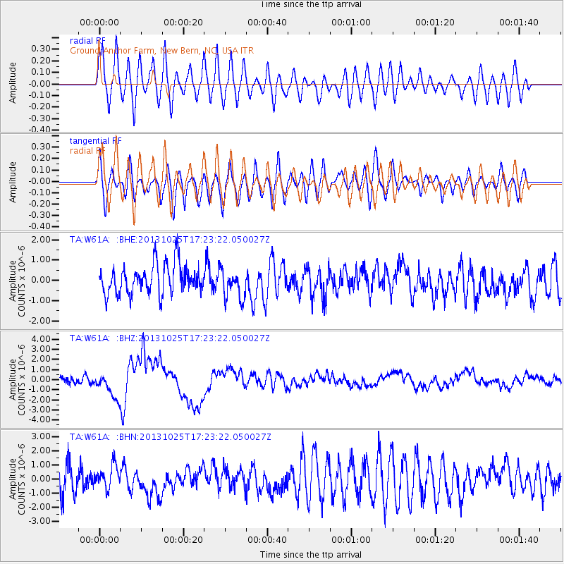
W61A Ground Anchor Farm, New Bern, NC, USA - Earthquake Result Viewer
*The percent match for this event was below the threshold and hence no stack was calculated.
| Earthquake location: |
Off East Coast Of Honshu, Japan |
| Earthquake latitude/longitude: |
37.2/144.7 |
| Earthquake time(UTC): |
2013/10/25 (298) 17:10:19 GMT |
| Earthquake Depth: |
35 km |
| Earthquake Magnitude: |
7.1 MWW, 7.1 MWW, 7.1 MWB, 7.1 MWC, 7.2 MWC, 7.5 MI |
| Earthquake Catalog/Contributor: |
NEIC PDE/NEIC COMCAT |
|
| Network: |
TA USArray Transportable Network (new EarthScope stations) |
| Station: |
W61A Ground Anchor Farm, New Bern, NC, USA |
| Lat/Lon: |
35.18 N/76.99 W |
| Elevation: |
6.0 m |
|
| Distance: |
98.3 deg |
| Az: |
33.379 deg |
| Baz: |
327.549 deg |
| Ray Param: |
$rayparam |
*The percent match for this event was below the threshold and hence was not used in the summary stack. |
|
| Radial Match: |
78.00507 % |
| Radial Bump: |
400 |
| Transverse Match: |
62.002758 % |
| Transverse Bump: |
400 |
| SOD ConfigId: |
626651 |
| Insert Time: |
2014-04-19 06:19:58.228 +0000 |
| GWidth: |
2.5 |
| Max Bumps: |
400 |
| Tol: |
0.001 |
|
Signal To Noise
| Channel | StoN | STA | LTA |
| TA:W61A: :BHZ:20131025T17:23:22.050027Z | 4.773065 | 1.2702042E-6 | 2.6611917E-7 |
| TA:W61A: :BHN:20131025T17:23:22.050027Z | 1.0701172 | 8.2094897E-7 | 7.67158E-7 |
| TA:W61A: :BHE:20131025T17:23:22.050027Z | 1.0414921 | 7.537164E-7 | 7.2368897E-7 |
| Arrivals |
| Ps | |
| PpPs | |
| PsPs/PpSs | |


