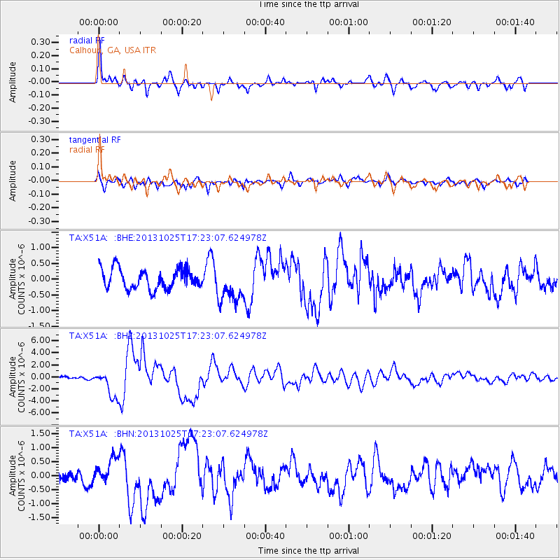
X51A Calhoun, GA, USA - Earthquake Result Viewer

Earthquake location: Off East Coast Of Honshu, Japan
Earthquake latitude/longitude: 37.2/144.7
Earthquake time(UTC): 2013/10/25 (298) 17:10:19 GMT
Earthquake Depth: 35 km
Earthquake Magnitude: 7.1 MWW, 7.1 MWW, 7.1 MWB, 7.1 MWC, 7.2 MWC, 7.5 MI
Earthquake Catalog/Contributor: NEIC PDE/NEIC COMCAT
Network: TA USArray Transportable Network (new EarthScope stations)
Station: X51A Calhoun, GA, USA
Lat/Lon: 34.57 N/84.86 W
Elevation: 214 m
Distance: 95.1 deg
Az: 39.062 deg
Baz: 322.405 deg
Ray Param: 0.040864103
Estimated Moho Depth: 36.25 km
Estimated Crust Vp/Vs: 2.06
Assumed Crust Vp: 6.35 km/s
Estimated Crust Vs: 3.086 km/s
Estimated Crust Poisson's Ratio: 0.35
Radial Match: 84.06011 %
Radial Bump: 400
Transverse Match: 68.639534 %
Transverse Bump: 400
SOD ConfigId: 626651
Insert Time: 2014-04-19 06:20:09.326 +0000
GWidth: 2.5
Max Bumps: 400
Tol: 0.001

Signal To Noise

ChannelStoNSTALTA
TA:X51A: :BHZ:20131025T17:23:07.624978Z10.8469192.365694E-62.1809824E-7
TA:X51A: :BHN:20131025T17:23:07.624978Z1.60333964.7352924E-72.9533933E-7
TA:X51A: :BHE:20131025T17:23:07.624978Z1.78430785.65667E-73.170232E-7
Arrivals
Ps6.1 SECOND
PpPs17 SECOND
PsPs/PpSs23 SECOND